

So Windy And Cold At Midday, The Bright Sunshine Is Not Helping Much

All of the western half of Central Alabama is now basking in bright sunshine as we approach the midday hour, while clouds are still continuing to cover the eastern skies. The good news is that the cloud cover will be out of here by the next couple of hours, and all will be clear by sunset.
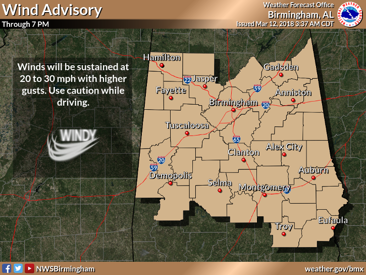
Unfortunately, we can’t enjoy the nice sunshine after a weekend filled with rainfall, due to the high gradient winds we are experiencing which are making the current temperatures feel much cooler. NWS Birmingham has issued a Wind Advisory for all counties in Central Alabama until 7 PM tonight due to sustained winds of 20 to 30 MPH with higher gusts.
Temperatures are ranging from the mid-40s to the lower 50s at 11:55 AM across Central Alabama. Tuscaloosa is the warm spot at 52 degrees.
Weather For The Rest Of Your Monday
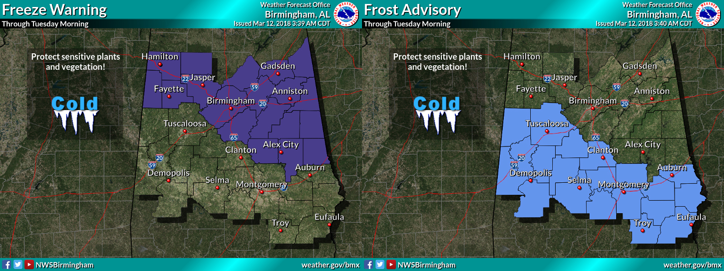
We will continue to have clearing skies through the remainder of the afternoon hours, with gusty winds at times and cool temperatures. Afternoon highs will be in the lower to mid-50s, but with the wind you can expect those temperatures to feel up to 8-10 degrees cooler at times. For tonight, winds will calm down and temperatures will make their trek into the cold category, as overnight lows will be in the upper 20s to the mid-30s. NWS Birmingham has issued a Freeze Warning and a Frost Advisory for parts of the area starting late tonight through tomorrow morning.
Tuesday Remains Cool But Wind Will Be A Little Less

High pressure starts to build in over the north-central plains sending more cooler continental air down into Central Alabama. Skies will be mainly sunny with just a few clouds floating overhead. Winds will be out of the northwest at 7-14 MPH, and that will make temperatures feel up to 5 degrees cooler at times. Afternoon highs will range from the lower 50s to near 60s degrees from north to south. Freeze Warnings and Frost Advisories will be likely again for tomorrow night and into Wednesday morning as lows will drop down into the mid-20s to the lower 30s.
Beach Forecast Center
Don’t you wish you were there, already? Soaking up the rays and wiggling your toes in the sand? Get the latest forecast for the beaches from Fort Morgan to Panama City on our Beach Forecast Center page. There, you can select the forecast of the region that you are interested in.
WeatherBrains
Don’t forget you can listen to our weekly 90 minute netcast anytime on the web at WeatherBrains.com or on iTunes. This is the show all about weather featuring many familiar voices, including the meteorologists at ABC 33/40.
E-Forecast
Get the AlabamaWx Weather Blog’s Seven-Day Forecast delivered directly to your inbox by email twice daily. It is the most detailed weather forecast available in Central Alabama. Subscribe here… It’s free!
Advertise With Us
Don’t miss out! We have enjoyed nearly 3.3 MILLION page views on AlabamaWx.com since the start of 2018. We can customize a creative, flexible and affordable package that will suit your organization’s needs. Contact Bill Murray at (205) 687-0782.
On This Day In Weather History
2006 – High school senior Matt Suter survives being blown 1,307 feet by a tornado. (The exact distance is determined by NWS GPS.) The twister rips open his grandmother’s mobile home and tosses Suter into the night, launching him over a barbed wire fence and eventually depositing him on the soft grass in an open field. He suffers only a head wound from being hit by a lamp.
Category: Alabama's Weather, ALL POSTS
About the Author (Author Profile)
Scott Martin is an operational meteorologist, professional graphic artist, musician, husband, and father. Not only is Scott a member of the National Weather Association, but he is also the Central Alabama Chapter of the NWA president. Scott is also the co-founder of Racecast Weather, which provides forecasts for many racing series across the USA. He also supplies forecasts for the BassMaster Elite Series events including the BassMaster Classic.Subscribe
If you enjoyed this article, subscribe to receive more just like it.


