A Much Improved Midday Over Yesterday’s Weather
Conditions Across Central Alabama At 1:30 PM
Absolutely clear skies across Central Alabama as we are getting closer to the middle of the afternoon. Temperatures are currently ranging from the lower 60s to the upper 60s throughout the area, which is well warmer than where we were at just 24 hours ago. Birmingham was at 64 degrees, while the warm spot was Tuscaloosa at 68 degrees.
Weather For The Rest Of Your Thursday
For the rest of the afternoon and early evening hours, skies will remain clear and temperatures will be mild. Afternoon highs will top out in the mid to upper 60s throughout the area. For tonight, we’ll continue to have mainly clear skies and temperatures will be quite warmer. Overnight lows will be in the upper 30s to the mid-40s.
A Dry Friday To Start, But Showers Move In Later On
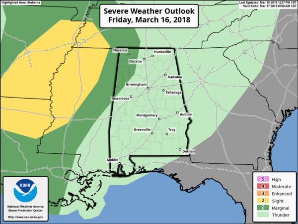
The first part of the day will start off with mostly cloudy skies and dry, but scattered showers will start to move into the western parts of the area just after the midday hour. Those showers will make it across the area throughout the afternoon and evening hours, but with those being scattered in nature, it will not rain all day and not everyone will get rain. Afternoon highs will be in the upper 60s to the mid-70s. The chance of scattered showers will continue on throughout the late night and overnight hours. Some thunder will be possible, but no severe weather is expected for much of Central Alabama.
The SPC has the extreme northwestern corner of Central Alabama defined in a marginal risk for severe storms, but we still believe the main threat will stay west of the state. We still may have a strong storm, and with this being the spring severe weather season in Alabama, we’ll keep our eyes on the situation.
Beach Forecast Center
Don’t you wish you were there, already? Soaking up the rays and wiggling your toes in the sand? Get the latest forecast for the beaches from Fort Morgan to Panama City on our Beach Forecast Center page. There, you can select the forecast of the region that you are interested in.
WeatherBrains
Don’t forget you can listen to our weekly 90 minute netcast anytime on the web at WeatherBrains.com or on iTunes. This is the show all about weather featuring many familiar voices, including the meteorologists at ABC 33/40.
E-Forecast
Get the AlabamaWx Weather Blog’s Seven-Day Forecast delivered directly to your inbox by email twice daily. It is the most detailed weather forecast available in Central Alabama. Subscribe here… It’s free!
Advertise With Us
Don’t miss out! We have enjoyed nearly 3.3 MILLION page views on AlabamaWx.com since the start of 2018. We can customize a creative, flexible and affordable package that will suit your organization’s needs. Contact Bill Murray at (205) 687-0782.
On This Day In Weather History
1989 – Afternoon and evening thunderstorms produced severe weather from Alabama to the Middle Atlantic Coast. Thunderstorm winds gusted to 80 at Virginia Beach VA. Low pressure in southeastern Ontario produced high winds in the northeastern U.S. Winds gusted to 70 mph at Saint Albins VT.
Category: Alabama's Weather, ALL POSTS


