

A Look At The Alabama Weather Situation
ACTIVE SPRING WEATHER: First off, severe weather threats like this are VERY common in Alabama in March, April, and May. There is absolutely no need to be fearful, just be prepared. Knowledge is powerful and this post will tell you what you need to know.
The primary severe weather concern will be tomorrow afternoon and evening, but we will deal with periods of rain, and possibly a few thunderstorms tonight as a warm front begins to lift northward through Central Alabama. SPC continues to mention a threat of severe storms for the southern half of Alabama tonight… the main threat will come from strong gusty winds and small hail. The tornado threat for South Alabama tonight is very low.
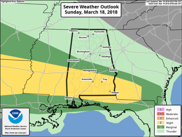
TOMORROW AFTERNOON/EVENING: SPC continues an “enhanced risk” of severe storms for much of North Alabama… the standard “slight risk” extends as far south as Linden, Camden, and Andalusia. A “marginal risk” covers the rest of Southwest Alabama…

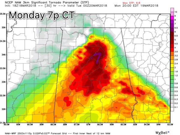
New model guidance this afternoon (the 18Z run of the 3km NAM) continues to show a volatile setup tomorrow afternoon; the combination of instability, shear, and strong wind fields are pushing the STP (Significant Tornado Parameter) up to a max of 6.8 over North Alabama tomorrow evening…
TIMING: The core risk of severe storms will come from roughly 3:00 until 10:00 p.m. A few storms over far East Alabama could linger through midnight.
THREATS: Storms tomorrow afternoon and evening could produce very large hail (2″ in diameter in some cases), damaging straight line winds, and a few tornadoes. One or two strong tornadoes are possible, mainly in the enhanced risk area over North Alabama.
RAIN: Storms will be fairly scattered in nature, and rain amounts where storms pass through should be around 1/2″. Some places will see lighter amounts. There is no significant risk of flash flooding.
CONFIDENCE: There is still a bit of uncertainty in that we will have rain at times tonight that might impact the atmospheric conditions tomorrow, but overall confidence in severe thunderstorm development is high. We will be looking for small scale boundaries that result in backed, southeast surface winds bringing a localized higher tornado threat tomorrow. We really won’t know about those until mid-morning tomorrow.
SCHOOLS: Some school systems are closing early tomorrow; see a list from ABC 33/40 here. They will be posted there as we learn about them.
CALL TO ACTION: Tonight is a good time to review your tornado plan.
*Be sure you can hear warnings if needed. NEVER rely on an outdoor warning siren; if that is your main way of hearing warnings, you have little hope of hearing them indoors. Have a NOAA Weather Radio in your home or business, and a good app designed for warnings on your smart phone like WeatherRadio by WDT.
*Know the safe place in your home. Small room, lowest floor, away from windows, and near the center of the house. If you live in a mobile home, you have to leave and go to a shelter or site built structure.
*In your safe place, be sure you have a helmet for everyone to wear (not just children)… it is also good for everyone to have a portable air horn (to get the attention of first responders if you need help), and be sure and wear hard sole shoes (you don’t want to walk over a tornado debris field with tennis shoes, or bare feet).
Stay tuned to the blog for updates!!
Category: Alabama's Weather, ALL POSTS
About the Author (Author Profile)
James Spann is one of the most recognized and trusted television meteorologists in the industry. He holds the AMS CCM designation and television seals from the AMS and NWA. He is a past winner of the Broadcast Meteorologist of the Year from both professional organizations.Subscribe
If you enjoyed this article, subscribe to receive more just like it.


