

Severe Weather Threat is on Track for Alabama Later Today, Tonight
The NWS in Birmingham has issued its severe weather risk outlook for today. Here is their latest impact graphic:
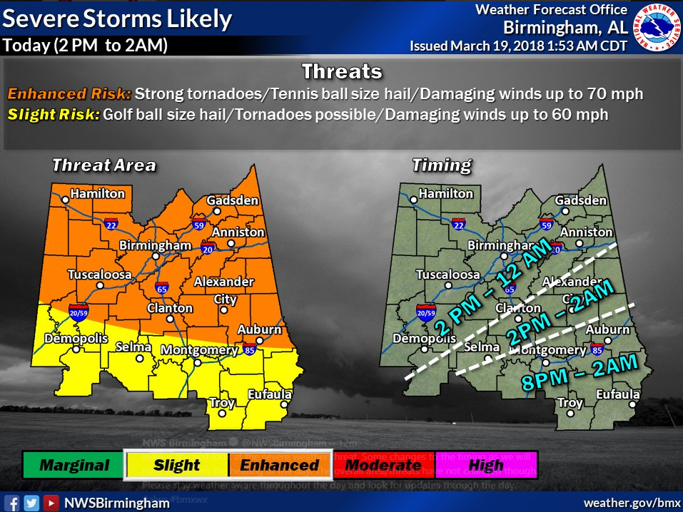
The thinking is still in line with what we have been saying:
…A surface low is over the Oklahoma Panhandle. It will move eastward to southern Kentucky by this evening
…A frontal boundary is situated over South Central Alabama. It will come northward this morning as a warm front in response to the surface low. It should reach Birmingham by mid to late morning. There could be a few storms along the warm front as it lifts northward. They could be briefly severe with hail and strong winds.
…There are already storms over North Central Mississippi ahead of the warm front and low-level jet that prompted severe thunderstorm warnings in the Mississippi Delta. These storms will impact West Central and Northwest Alabama between 530 and 8 a.m. CDT.
…South of the warm front, dew points will be in the 60s, rising into the upper 60s in many spots by afternoon.
…A strengthening upper-level trough and strong jetstream level winds will swing eastward today and tonight, enhancing lift for storms.
…A strong low-level jet (5,000) feet or 850 mb) of 45-50 knots will spread across Mississippi and into Alabama this afternoon.
…These strong low-level southwesterly winds, along with strong westerly winds running 70 knots at 500 mb, or 18,000 feet, will provide sufficient deep layer wind shear, which will favor supercell thunderstorms this afternoon over North Alabama. This deep layer shear will overspread the rest of North and Central Alabama into the evening hours.
…There will be plenty of instability, with CAPE values running over 2,000 joules/kg. This will support powerful thunderstorm updrafts.
…Strong thunderstorms will start forming over southern Tennessee by early afternoon and will continue developing into North Alabama by mid-afternoon. These storms may affect the Huntsville area as well as other parts of the Tennessee Valley.
…A line of storms will form over northern Mississippi by late afternoon, spreading into Northwest Alabama by 5-7 p.m. CDT. These storms will quickly intensify over West Alabama, reaching the I-59 Corridor between 9-11 p.m. CDT.
…Storms that form just ahead of the main line will encounter the most favorable instability and shear combination, which would make them especially dangerous. It remains to be seen whether that can happen, with a strong capping inversion potentially helping to keep a lid on the atmosphere.
…Instability values will drop after sunset as we lose the heating of the day, and hopefully storms will lose some of their punch as they progress eastward.
…Storms will have the potential to produce very large hail, as large as two inches or greater in diameter. Damaging straight line winds will be a threat as well.
…Tornadoes will also be possible, including the possibility of a few strong tornadoes, especially for areas in the enhanced threat area that includes Hamilton, Tuscaloosa, Birmingham, Clanton, Alex City, Auburn, Anniston and Gadsden.
Note that there are slight differences in the NWS Birmingham threat area and the Storm Prediction Center Day One Severe Weather Outlook. Do not focus on those small differences. The threat for severe weather is significant for all of Central and North Alabama for this afternoon and tonight.
Please review your severe weather safety plan and make sure you have a way of receiving warnings throughout the event. Have your severe weather safety kit close to your safe place and make sure all family members, friends, neighbors and co-workers are aware of the situation.
Stay with us all day and night on the AlabamaWX blog for continuous updates. We will be operating in high-traffic mode throughout the event in order to handle the high volume of readers.
Category: Alabama's Weather, ALL POSTS
About the Author (Author Profile)
Bill Murray is the President of The Weather Factory. He is the site's official weather historian and a weekend forecaster. He also anchors the site's severe weather coverage. Bill Murray is the proud holder of National Weather Association Digital Seal #0001 @wxhistorianSubscribe
If you enjoyed this article, subscribe to receive more just like it.


