Snow, cold air update
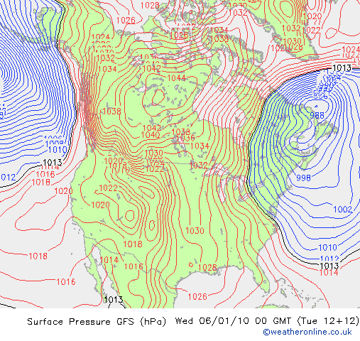
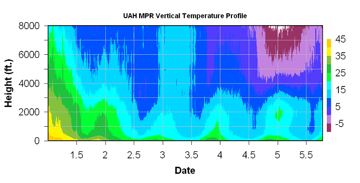
Northerly flow around a high to our NW and a low to our NE continues to bring extremely cold air into Alabama. This map has looked almost the same for days now…that’s what happens with an extremely negative Arctic Oscillation (AO) (for details, see here). You can see in the following time-height section of temperatures from the UAH MPR that the cold air keeps getting deeper. The daily bubbles of heating are interesting. I’ll get to the snow in a minute.
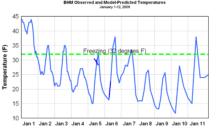
At 1 pm, it was still 30 in BHM, 32 in GAD, 31 in Cullman, and 28 in HSV. Temperatures were above freezing at TCL and ANB at 33, and it was 35 in MGM. Another very cold day, and if the thermomemeter doesn’t get moving, it will be the second consecutive day Birmingham has not climbed above freezing.
The little line across the temperature graph shows where it transitions from observed, past temperatures to forecast, future temperatures. in BHM, we have been below freezing continuously for 45 hours, and during 80 of the last 110 hours. If the forecast for even colder air holds up for the weekend (and we have high confidence in the cold air part), we could go below freezing again Thursday afternoon and stay until Monday afternoon, a period of about 84 hours, with lows near 10 and highs in the 20s over the weekend. We can’t stress enough that every precaution needs to be taken regarding pets, the elderly, water pipes, and energy. See some of our posts from previous days for tips on those items. This cold outbreak will be historic, and we will look back on it for many years, as we did the 1989 cold outbreak. My boss told me that the power was blinking a little yesterday morning in Madison, AL, likely due to the extreme load of heat pumps running.
Now for the snow. Model amounts are starting to stabilize a little now. For BHM, here are the model predictions, using a 12:1 snow to water ratio: NAM 2.2″, GFS 1.5″, European 1.25″, Canadian 1.75″. It does look like the heaviest amounts will be south of Birmingham, near Clanton or so. Montgomery could see 1″ also. It looks like the snow will move in during the day on Thursday, just before daybreak in west Alabama, and into east Alabama by noon. The window for BHM is mainly 9 am through 5 pm.
The models should stabilize further on timing and amounts by tomorrow morning, as the system finally gets going. Right now, it looks like the big time Gulf moisture needed for heavy snow (6″+) will not make it here, but subtle changes in the position of upper-level waves and surface lows, nearly impossible to predict now, could make a big difference.
Category: Uncategorized


