Flash Of Light – Mystery Solved!
Here is the results of the research done by Bill Cooke of Marshall Space Flight Center’s Space Environments Team in Huntsville… bottom line was that this was a 21 inch rock with a trajectory from NE to SW with a fall zone potentially in Central or South-Central Mississippi.
“Can confirm that this was indeed a fireball or bolide. Unfortunately no video of the actual meteor has surfaced, so I requested an analysis of signals from North American infrasound stations. We had one very clear detection, from the ELFO station in Canada, and a marginal signal at another station east of the visual sightings. Unfortunately the marginal signal is too weak to permit extraction of much information or to triangulate.
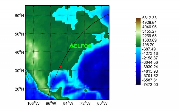
The ELFO signal arrived at 10:05:50 PM Central time, some 1 hour and 20 minutes after the event, and came in at an azimuth of 210 degrees. I you look at the attached plot, the black curved line shows the path of the ELFO signal, which intersects nicely with the bulk of the visual observations – indicated by the red dot – around Jackson, Mississippi (ELFO az gives 32 deg N, 89 deg W – Jackson is at 32 deg N, 90 deg W).
The infrasound signal at ELFO lasted some 2.5 minutes, and the amplitude permits an estimate of the meteor’s energy at 4.6 tons of TNT. If we assume a speed of 15 kilometers per second, we can derive a mass of 171 kg or 376 pounds. Making a further assumption that the meteor was porous rock gives a size (diameter) of 0.54 meters or 21 inches.
That’s the best estimate at this time – if video data of the meteor itself shows up, please let me know. Don’t hesitate to ask questions if you need clarification or more information.
Regards,
Bill”
And, this information below is from meteorite hunter Rob Matson…
“Based on these 4 reports:
Slidell, LA: north, moving R–>L
Greenville, MS: east, moving L–>R
Montgomery, AL: west, moving R–>L
Memphis, TN: south, moving L–>R
it looks like the fall zone is in central or southcentral
Mississippi, and the bolide trajectory was from NE to SW.
I checked the real-time radars (which are only for the lowest
elevation angle) and there’s nothing obvious. So we’ll have
to wait for the full level-II data. –Rob”
Category: Hodgepodge


