Afternoon Forecast Update
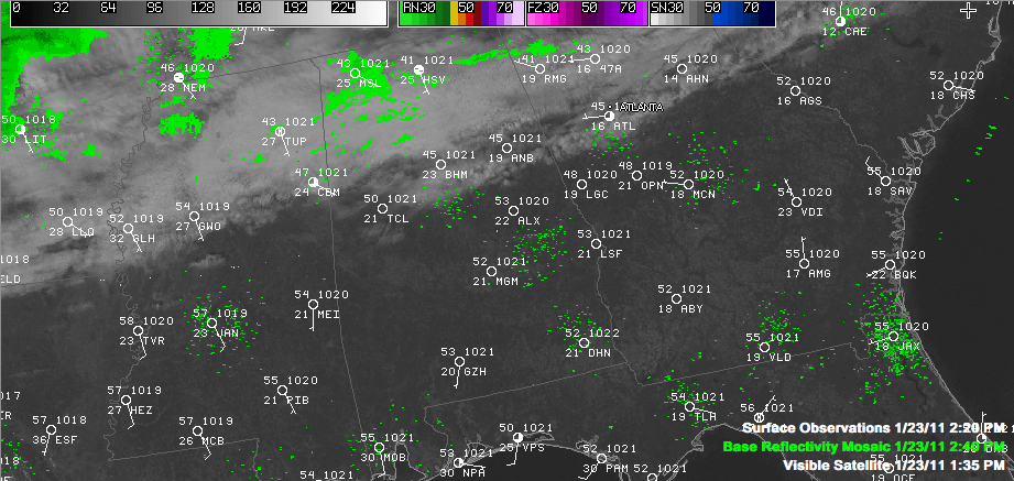
High clouds streaming across the northern half of the state have blocked much of the sunshine and caused temperatures to struggle to get out of the 40s this afternoon. Once you get south of Calera, skies become sunny and temperatures have warmed to above 50F. Over Northeast Alabama, temperatures have struggled to get out of the 30s thanks to the clouds and an easterly wedge nosing into the state from Georgia.
Those radar echoes over Northwest Alabama are very light and not reaching the ground for the most part, although I wouldn’t rule out a few sprinkles in that area.
TONIGHT: Tonight should feature fair skies south, with continued mostly cloudy conditions north. Temperatures should bottom out in the lower and middle 30s, with areas under clear skies actually getting colder. It now looks like we might get through the day on Monday with little in the way of showers. There could also be a little more sunshine, which might let the mercury make the 50s. Those showers will finally arrive Monday night, with lows dropping to near 40F.
TUESDAY THREAT: We have been fairly confident that a low pressure system would develop over the western Gulf of Mexico and track eastward this week. That looks on track. With cold air in place over the South, that can be a recipe for wintry precipitation. The devil is in the details, as they say.
THE DETAILS: The track and intensity of the low are critical. On Saturday, it appeared that the low would be in the perfect sweet spot to bring snow to North and Central, and perhaps even South Alabama. Far enough to the south not to bring too much warm air north, yet strong enough to throw moisture into the cold air and draw more cold air in on the backside of the system as it roared up the coast. Think 1993 Superstorm, on a smaller scale.
Well, one model saying that by itself is one thing, but our two major models and their European counterpart chiming in with the same solution, that sets off alarm bells in the old weather office. Since Saturday morning the models have not been as bullish on the idea of the big low being in the right spot for a significant accumulating snow.
But for now, confidence is increasing in a forecast that includes rain to be rain spreading into the area early during the day on Tuesday, possibly mixing with snow over the northern half of the area late Tuesday night and continuing into Wednesday morning. There still could be some surprises with this system, including the possibility of some accumulations late Tuesday night into Wednesday in places where something we call dynamic cooling occurs with the strong upper system aloft moving overhead.
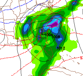
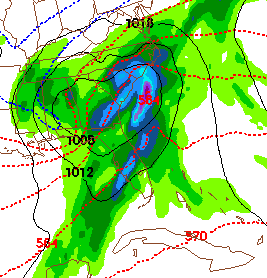
Here is the look for after midnight early Wednesday from the GFS and the NGM.
The dotted blue line reflect the models’ ideas of roughly where it could be cold enough for the rain to mix with snow. Dynamic upper systems like this one though can fool the models and make a colder atmospheric temperature profile that can support snow. Hence the idea that surprises are not off the table with this one.
Wednesday will be cool and blustery with a freshening northwesterly wind as the low pressure system intensifies and gets ready to head up the East Coast as a blockbuster storm. Skies should clear during the day and highs will only be in the 40s.
Category: Alabama's Weather, Winter Weather


