The Week Ahead
Yet another challenging week ahead for Alabama meteorologists. Everybody is looking for answers that quite frankly can’t be handled very well more than 48 hours in advance. I am getting email and Facebook and Twitter messages from people telling me that various people are forecasting a “historic” snow for Alabama this week, and they want to know what I think.
Long time blog readers know my usual response… I honestly don’t care about what anybody else says, I simply don’t have the time or interest. All we do here is tell you what we think will happen with full explanation and openness.
This is where we are right now…
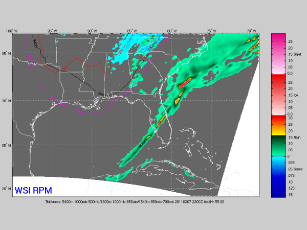
MONDAY: The first wave of the week will bring some light rain to the state Monday, with some risk of a little light snow on the back side of the departing system Monday evening. Here is the RPM output below for 4:00 p.m. CST Monday… showing the most widespread snow over the northern quarter of the state, and it is very light…
There could be a dusting of snow for that part of Alabama Monday evening, but precipitation should be pretty light.
WEDNESDAY/THURSDAY: If we are going to get a big winter storm, this is the time. Again, there is not much skill in forecasting snow placement and amounts more than 48 hours in advance around here. Why some people choose to do it is a little baffling.
The GFS has been advertising a big North Alabama snow for a number of runs, but it has backed off in recent runs. Below is a look at the forecast snow for Birmingham from the GFS using BUFKIT data:
The last few GFS runs, as you can see, are now printing only a dusting to 1.2 inches for Birmingham. Runs from yesterday were in the 6 to 10 inch range.
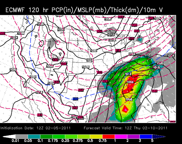
The ECMWF, which has performed pretty well this season, is now more aggressive. Below is the output valid Thursday morning at 6:00 a.m. CST…
That would suggest a very good snow for the northern third of Alabama.
BIG TIME COLD: Aside from the snow, some very cold air will come in here late in the week… you can see the GFS in recent runs is suggest mid-teens by Friday morning… the runs were colder yesterday with 0 degrees (F) showing up…
BOTTOM LINE: There is a chance of some significant snow for parts of Alabama (most likely the northern counties) Wednesday night into Thursday morning, but it is way too early to be specific on amounts or placement. And, it will turn much, much colder at the end of the week, perhaps the coldest air so far this season.
All of the armchair meteorologists will probably make wild forecasts of big snow, and who knows, they might right, but NOBODY right now knows. I recommend this weekend you spend some time with your family, take a long walk, get a little fresh air, and relax. The 48 hour rule means the first snow accumulation potential graphic won’t show up here until Monday night, most likely.
Enjoy the weekend!!!!
Category: Alabama's Weather


