

From the Storm Prediction Center…
From the Storm Prediction Center…
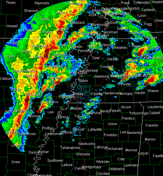
MESOSCALE DISCUSSION 0169
NWS STORM PREDICTION CENTER NORMAN OK
0807 PM CST TUE FEB 05 2008
AREAS AFFECTED…SE MO…ERN AR…WRN TN…NRN/WRN MS
CONCERNING…TORNADO WATCH 36…37…
VALID 060207Z – 060330Z
THE SEVERE WEATHER THREAT FOR TORNADO WATCH 36…37…CONTINUES.
PRIMARY SUPERCELL CLUSTER IN WARM ADVECTION REGIME NEAR/NORTHEAST OF SOUTHERLY LOW-LEVEL JET CORE WILL SHIFT EAST/NORTHEASTWARD TOWARD THE UPPER OHIO VALLEY WITHIN NEXT FEW HOURS. BUT…SEVERE THREAT WILL PERSIST FROM THE CONFLUENCE OF THE OHIO/MISSISSIPPI RIVERS…SOUTHWARD THROUGH THE LOWER MISSISSIPPI VALLEY…UNTIL PRE-FRONTAL SQUALL PASSES DURING THE 03-06Z. BY 06Z…THE COLD FRONT IS EXPECTED TO SURGE INTO THE VICINITY OF THE RIVER…TO THE SOUTH OF A SLOWLY DEEPENING SURFACE LOW MIGRATING INTO SOUTHERN ILLINOIS/INDIANA. PRE-FRONTAL SQUALL LINE MAY BE NEAR OR JUST EAST OF EVANSVILLE IN…JACKSON TN…TUPELO AND JACKSON MS BY THIS TIME.
WHILE LOW-LEVEL FLOW FIELDS MAY TEND TO WEAKEN SOME…LOW-LEVEL SHEAR WILL REMAIN MORE THAN SUFFICIENT TO MAINTAIN A RISK FOR TORNADOES WITH CELLS WITHIN…AND JUST AHEAD OF /BEFORE MERGING INTO/…LINE. HOWEVER…WITH A CONTINUED STRENGTHENING OF SOUTHWESTERLY MID-LEVEL FLOW…WITH 500 MB SPEEDS IN EXCESS OF 100 KT…INTO THE REAR OF LINE…DAMAGING WIND POTENTIAL MAY BECOME THE PRIMARY THREAT…AS EVAPORATIVE COOLING IN DRY MID TROPOSPHERIC LEVELS AIDS DOWNWARD MOMENTUM TRANSPORT TO THE SURFACE.
.KERR.. 02/06/2008
The squall line is approaching the Mississippi River. It will continue to surge eastward overnight. Wind shear will be sufficient to produce tornadoes in any thunderstorms ahead of the line and in the storms in the line overnight…
This radar depicts the situation…
Severe weather will affect Alabama late tonight. This has the potential to become a widespread damaging wind event, in addition to the possibility of tornadoes.
Please rehearse your severe weather plan and be prepared to implement it on a seconds notice overnight.
Category: Uncategorized
About the Author (Author Profile)
Bill Murray is the President of The Weather Factory. He is the site's official weather historian and a weekend forecaster. He also anchors the site's severe weather coverage. Bill Murray is the proud holder of National Weather Association Digital Seal #0001 @wxhistorianSubscribe
If you enjoyed this article, subscribe to receive more just like it.


