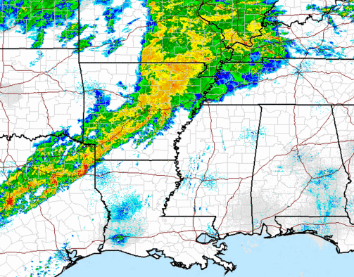
Severe weather analysis – 230 am
…Severe storms possible over Alabama today and tonight but tornado threat minimal…
A cold front is located from AR into TX early this morning, and it will move through Alabama this evening. Out ahead of it, heavy rain and thunderstorms already cover much of AR and TX, with numerous flash flood warnings in effect. There were 1 or 2 severe thunderstorm warnings at 210 am, but no tornado warnings that I could find.
As this system pushes east today, especially with warm, humid air in place over Alabama, we expect showers and thunderstorms, with the best chance from late afternoon through evening. The latest model runs show the strong wind shear farther north, near the surface low (NW of Memphis). That low will move NE into Kentucky and Indiana today, so winds at the surface should stay more out of the SW instead of the SE around here, limiting wind shear somewhat. This is not to say there will be no wind shear, but the strongest shear will be north and the strongest instability south. It still looks like a line of storms, with the threat of damaging winds, heavy rain, and maybe an isolated tornado or two, will move into NW Alabama by 2 or 3 pm, into BHM by early evening, and east Alabama by 10 or 11 pm.
Even with temperatures in the 70s and dewpoints in the 60s, mid-level temperatures are not very cold, so the air will not be that unstable (CAPE less than 1,000 J/kg in BHM). And, with the surface low staying north, unless something changes, the wind shear will too, with the peak helicity values in BHM around 200 m2/s2.
THIS IS NOTHING LIKE APRIL 27. If you recall on April 27, we emphasized the energy-helicity index as an indicator of tornado potential (unstable air and wind shear together). On April 8, 1998, the EHI was 6. On April 27, 2011, it was 12. Today, it may reach 1 or 1.5 somewhere in northern Alabama, sufficient for isolate, mainly small tornadoes, but it won’t be a major outbreak.
Still, you should keep a source of weather info handy today and tonight, and have a plan ready in case of a tornado warning. All it takes is a single F0 or F1 tornado knocking a large tree on your house to cause serious injuries, so just because it is not like April 27, still take it seriously and go through your tornado safety plan if a warning is issued for your area.
The good news is most of us should get 1″ of rain out of this storm.
Category: Severe Weather


