Why has it been so warm lately?
(policlimate.com)
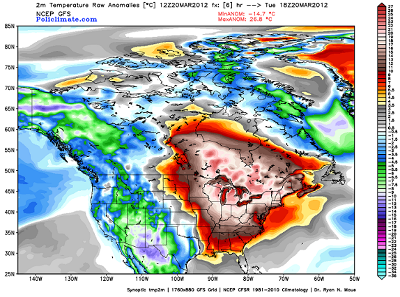
The above map shows temperature anomalies (degrees above or below normal) over the USA and Canada yesterday. Notice the huge area of above normal temperatures covering the eastern half of the country…as much as 20 C (35 F) above normal in the Great Lakes area, and about 11 C (20 F) above normal from Alabama all the way to Hudson Bay. The temperatures over the eastern half of the US since last Monday have been more like late May or even early June than March. However, notice the western half of the country. Temperatures are way below normal. As much as 12 C (22 F) below normal in Arizona and New Mexico.
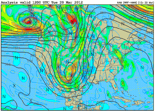
Since the upper air winds tend to mirror the temperatures (troughs in cold air and ridges in warm air), there is a very intense trough in the west, and a huge ridge in the east. Check out the 500 mb chart from yesterday.
Instead of the usual west to east flow at upper levels, winds were diving south along the Pacific Coast, then turning north and going from Texas straight to Hudson Bay. So, the primary reason it is so warm here is because of the amplified flow, with very cold air in the western US/western Canada/Alaska and very warm air in the eastern US/eastern Canada. This system is finally cutting off over the Plains, producing heavy rain that is slowly moving our way.
I have discussed before (see number 1. in https://www.alabamawx.com/?p=56954) that weather systems like the big one over the US now are the way the atmosphere is balanced. A lot more sunshine comes in to the tropics than it does at the North Pole. If we didn’t have low pressure systems with cold fronts and warm fronts, moving cold air south and warm air north, it would eventually heat up to 150 F in some places in the tropics, while the Arctic would drop to -100F. But, these weather systems redistribute the heat so that doesn’t happen. The weather system over the country right now has been doing this. Cold air has moved from the Arctic all the way to Mexico, and warm air has moved from the Gulf and Caribbean north into Canada (via Alabama).
But why is this one so extreme? Record high temperatures have been broken by the hundreds over the past few days in the eastern US. I don’t have the answer for sure, but I have an idea of why it may be.
It is NOT global warming. Over the entire globe right now, the temperature is only 0.4 degrees above normal, and these oscillations are typical, and the global temperature will be below normal by next week according to the models.
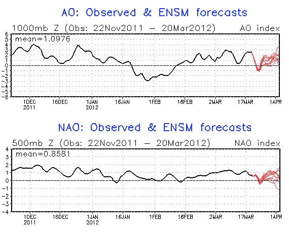
The extreme weather over the country right now may very well be because the winter in most of the US was so warm. We had a positive NAO, preventing Arctic air from making big moves into the US. The AO, a measure of how much cold air gets flushed out of the Arctic by weather systems over the whole Northern Hemisphere, was also mainly positive.
Because of the positive NAO and mainly positive AO, the cold air stayed locked up in the Arctic for most of the winter, and when it did move south, it mainly went into Europe. So, we had a warmer than normal winter, and Arctic areas like Alaska and Canada had colder than normal winters. One of the lowest temperatures ever recorded in the US occurred this winter in Alaska, and temperatures between -30 and -60 were widespread. (This is just the opposite of last winter and the winter of 2010, when the AO was negative. Cold air moved south often, and we had temperatures in the teens many nights in 2009-2010, and 4 snow events in 2010-2011, including a White Christmas. At the same time, the Arctic was warmer than normal).
The summary is that the atmosphere was very well-balanced in the past two winters, with cold air moving south and warm air moving north, keeping a really strong gradient from developing. This year, that has not happened as much. Just a week ago, temperatures were still near -50 in parts of the Arctic. I wonder if the imbalance created by the big temperature gradient between the Arctic and the midlatitudes (especially the US) this year is finally, naturally, being corrected.
Does this mean that there will be more big weather systems in late March and April? I don’t know. But, I would keep in mind that the average date of the last freeze in BHM is around March 25-30, and we have seen 20s well into April before. Hopefully, we’ll get some good rain out of this system as it finally presses toward Alabama.
Category: Met 101/Weather History


