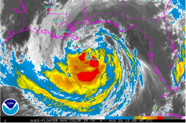
Isaac Slows Forward Speed, On Verge of Being Hurricane
Isaac remains a strong tropical storm this morning. Top winds are 70 mph. Isaac has an eye, 32 miles in diameter, but it is open on the southwest side. This indicates it is still not well organized, but it is on the verge still of becoming a hurricane. Storms continue to try to fill in around the center. When this happens, strengthening should commence.
The pressure continues to slowly fall. It is now 977 mb, which normally equates to a category one hurricane. But the very large size means that there is not a tight enough pressure gradient to produce the really strong winds.
The plane has found 90 mph flight level winds, but the highest surface wind estimates from the SFMR instrument still show 50 knots, or between 55-60 mph. I think this is the reason that the hurricane center still has not upgraded Isaac.
The advisory shows the storm is still moving northwest at 12 mph, but over the past few hours, it has slowed and is moving more west northwest. Between midnight and 4 a.m., it only moved 20 miles according to reconnaissance reports.
The track is basically the same. Click on the image to enlarge it and see the forecast points in red. It is forecast to make landfall at Barataria Bay or near Buras, near the mouth of the Mississippi River.
Category: Tropical


