Weather Update: Cold Air and Sandy
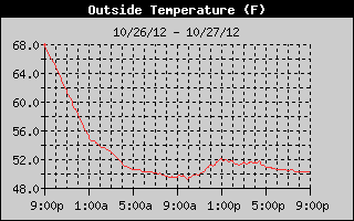
Cold air came into Alabama on the heels of a cold front which moved through the area last night. The temperature changed very little today as you can see from the temperature trace below. In fact, nearly all of the reporting stations in Central Alabama observed their high temperatures for the day at 12:01 am. The high at my house was 58, 4 degree higher than the Birmingham Airport just because I am a little south of the airport and it took the cold air a tad longer to get to me. Birmingham had a daily high of 54 observed just after midnight along while Anniston (56) and Tuscaloosa (55) observed their highs around 3 pm.
No rain is likely to occur in Central Alabama for the next week. But a whopping 9 to 11 inches of rain is expected just off the New Jersey coast with the approach of Sandy on Monday and Tuesday. Sandy is still shaping up to be a major storm with wide ranging effects for New England, the Mid-Atlantic coastal area, and much of Virginia, West Virginia, Pennsylvania, New York, New Jersey, North Carolina, Delaware, and Maryland. In fact, I expect to see some major disruptions to air travel on Tuesday, maybe beginning late Monday night, as airports along the Mid-Atlantic coast are impacted by Sandy.
The latest information from the National Hurricane Center showed Sandy was still a Category 1 hurricane with sustained wind at 75 mph. Radars along the North and South Carolina coastline showed the outer bands of Sandy affecting the coastal areas of North Carolina from Virginia Beach to Wilmington as Sandy passed 355 miles east-southeast of Charleston, SC. Wind along the North Carolina and Virginia coastal areas were blowing out of the northeast at 15 to 25 mph with gusts to near 35 mph. Sandy continued to move northeastward at 13 mph.
The movement of Sandy will continue northeastward through early Monday morning when it is expected to turn west-northwest before coming ashore along the Delaware/New Jersey coast very early Tuesday morning. Remember, though, that while the center may not cross the coast until early Tuesday morning, much of the western side of Sandy will have been impacting the area across parts of Virginia, Delaware, New Jersey, Maryland, North Carolina, Pennsylvania, and New York for many hours before that.
Rainfall of 4 to 7 inches can be expected through late Thursday across portions of Pennsylvania, Virginia, West Virginia, Delaware, New Jersey, and Maryland. Much of that area is already blanketed with flash flood watches, coastal flood watches, and even a winter storm watch for the western slopes of the Appalachians where 4 to 8 inches of snow will be possible. The NWS in Charleston, WV, has estimated that 1 to 2 feet of snow (yes, that’s feet) are possible at elevations above 3,000 feet.
The storm impacts will be big and cover a large area. Power outages, downed trees, wet snow, high wind, coastal flooding, flash flooding, and storm surge can all be expected. Four to 8-foot storm surge is currently being forecast from Ocean City, MD, to the Connecticut/Rhode Island line.
-Brian-
Category: Alabama's Weather


