An Update on the Severe Weather Threat
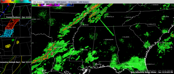
A line of strong thunderstorms is pushing eastward across eastern Texas, northwestern Louisiana, eastern Araknsas, the Missouri Bootheel and western Kentucky.
Storms have formed ahead of the line over western Tennessee ahead of the main line.
Some of the storms have been severe this afternoon and a few severe thunderstorm warnings remain in effect this evening over eastern Texas, central Arkansas and western Tennessee.
A tornado watch is in effect until 9 p.m. for areas from southern Illinois to eastern Arkansas. A severe thunderstorm watch was issued recently for areas southwest of the tornado watch back into eastern Texas. It goes until midnight.
The Storm Prediction Center maintains a slight risk outlook through the overnight hours for areas from east of Austin TX to Evansville IN. It just touches the northwestern corner of Alabama.
That’s the bad news. The good news is that there have been few severe weather reports so far. There was a tornado in northern Arkansas around 3:30 p.m. There have been 13 reports through 6:45 p.m., mostly damaging winds.
The other good news is that the storms are weakening. The instability feeding the storms is weakening with the loss of the heating of the day. This means that the storms will continue to weaken through the overnight hours.
The storms will reach Memphis between 9-10 p.m. and the northwestern corner of Alabama around 2 a.m. We can’t rule out a few damaging wind reports with these storms.
The concern is that an approaching disturbance rounding the base of a trough over the Rockies this afternoon will help intensify the storms over Central Mississippi after midnight. These storms will push into Northwest Alabama around 2-3 a.m., pushing into the Huntsville area by 4:30 a.m.
By then though, the storms should start weakening as the disturbance weakens. As the storm rolls into the I-59 corridor around 7-8 a.m., the storms should be slowly weakening.
While significant severe weather is not expected, there will probably be a few warnings over western sections before sunrise, in the I-59 corridor between 7-11 a.m. and over northeastern Alabama through early afternoon. Damaging winds and hail will be the threats. The chance of any small tornadoes is low.
Temperatures will quickly drop into the 40s tomorrow morning behind the cold front. The front should reach I-59 by late morning, with temperatures falling from the 60s into the 50s during the early afternoon.
Rainfall amounts in the I-59 corridor will average between 0.75-1.25 inches, with higher amounts to the northwest.
Turn your Weatheradio to alert mode before retiring for the night tonight, or make sure that you have a reliable smartphone app or weather calling system available to wake you just in case warnings are required overnight or early tomorrow morning.
We will have frequent updates throughout the night here on the blog.
Category: Alabama's Weather, Severe Weather


