

1:30 a.m. Update
Click to expand.
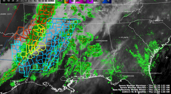
Our line of thunderstorms continues to move east this morning. It has just passed through Shreveport on I-20, where a few trees were reported down on West Lakeshore Drive at 1 a.m. There have been at least 41 reprots of high wind since just after 8 p.m. last night.
Four severe thunderstorms warnings are in effect now in Arkansas, Louisiana and southeastern Texas. One includes the areas generally between Shreveport and Ruston along I-20.
A tornado watch continues for parts of Oklahoma and Arkansas over to Little Rock, with a couple of severe thunderstorm watches covering areas east and south of the tornado watch. The newest severe thunderstorm watch covers areas from Memphis to west fo Jackson, MS on into southeastern Texas.
Ahead of this main line, showers continue to build over much of Mississippi and Central Alabama, extending into West Central Alabama. These showers aren’t producing lightning yet as the highest tops are around 20-25,000 feet. The heaviest precipitation was north and northeast of Columbus MSl including parts of Pickens and Lamar Counties in West Central Alabama.
This activity will continue to build through the overnight hours and spread northeast ahead of the main line of storms, which will arrive later this morning. There is a remote chance we could see a warning or two with the cells in advance of the main line, but the greater chance is later this morning with the main line.
Category: Alabama's Weather, Severe Weather
About the Author (Author Profile)
Bill Murray is the President of The Weather Factory. He is the site's official weather historian and a weekend forecaster. He also anchors the site's severe weather coverage. Bill Murray is the proud holder of National Weather Association Digital Seal #0001 @wxhistorianSubscribe
If you enjoyed this article, subscribe to receive more just like it.


