

Line Moving Faster
Click image to expand
Our line of thunderstorms (or really intense showers, since it has little lightning) has surged ahead this morning ahead of a strong cold front and is moving a little faster toward Central Alabama.
Instability is increasing over West Central Alabama rapidly and there is a very high amount of wind shear. Any updrafts that form will rotate and will have the potential to produce tornadoes. A tornado watch is in effect for much of West Central, South Central and Southwest Alabama until noon.
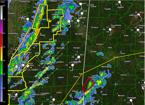
As always the case, cells ahead of the main line are of particular concern. The NWS Jackson issued a tornado warning one such cell which is about 15 miles southwest of Starkville at 5:10 a.m. This cell has had a history of triggering tornado vortex signatures. It has weakened in the past few minutes and the warning was allowed to expire. We will keep an eye on it.
The main line now extends from Oxford MS to west of Jackson. It is moving rapidly east at 45-50 mph. There are numerous kinks and bows in the line, which are indications of damaging winds. This is not surprising, given the very strong winds aloft. Winds gusted to 60 mph at Yazoo City in the past few minutes. A peak wind of 49 mph at Greenville MS as the line passes.
So the line looks unimpressive on radar reflectivity, but don’t let that fool you. It will be packing a punch as it comes through the area later this morning.
Timing looks like 6:30 for Lamar and Marion, 6:45-7 for Pickens and Sumter, 7:30 for Tuscaloosa and 8:30-9 for Birmingham.
Prepare for a fast moving line of low topped storms with little lightning, but lots of high wind and brief heavy rain this morning, preceded by the potential for individual storm cells that could produce quick spin up tornadoes that are hard to warn for.
In addition, it will be very windy even outside storms today. Look for sustained south winds at 20-35 mph with occasional higher gusts, especially on higher ridges.
Category: Alabama's Weather, Severe Weather
About the Author (Author Profile)
Bill Murray is the President of The Weather Factory. He is the site's official weather historian and a weekend forecaster. He also anchors the site's severe weather coverage. Bill Murray is the proud holder of National Weather Association Digital Seal #0001 @wxhistorianSubscribe
If you enjoyed this article, subscribe to receive more just like it.


