

Dangerous Severe Weather Threat Later Today/Tonight
Merry Christmas! I wish we had better news, but parameters are still coming together for the potential for a significant severe weather outbreak across Alabama and the Deep South later today and tonight. This is a long post, but like recent days, I encourage you to read all of this, and be sure and share the information with your friends, neighbors, family members, or anybody else. We won’t be able to reach large numbers of people today like usual due to the holiday.
THE SETUP: Brian Peters will be along shortly with a fresh meteorological discussion and a new Weather Xtreme video, which will give you the technical details.
On the maps, a well defined warm front is over South Alabama, near Alabama Highway 10 (Butler to Camden to Greenville to Troy to Abbeville. South of this front, dewpoints are in the 60s, and the air is very unstable. North of the front, the air is cool and stable with temperatures in the 40s.
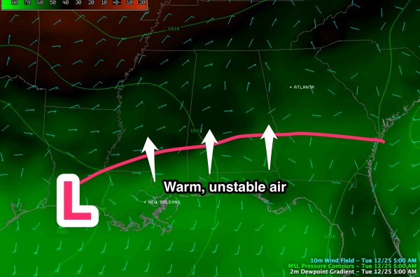
During the day, the warm front will move northward in response to a deepening surface low to the west, which will run from near Monroe, Louisiana to near Muscle Shoals. It is our belief that this warm front will be near U.S. 278 by late afternoon, and could very well reach the Tennessee border early tonight. This will put all of Alabama in the warm sector. So, it might feel cool where you are right now, that will change quickly later today.
All of the elements will be in place. Strong wind fields aloft and at the surface, very high levels of shear/helicity (veering of the wind with altitude), low LCL (lifted condensation level) heights, and an unstable airmass. The amount of instability is the only limiting factor, but we have all learned that significant tornadoes in Alabama can, and will happen with moderate CAPE (convective available potential energy) values.
TIMING: Severe weather could break out over West Alabama as early as 3:00 this afternoon. The main 12 hour window for severe weather remains 3:00 p.m. today to 3:00 a.m. tomorrow, but the core of the threat will come from about 6:00 p.m. until 2:00 a.m. As usual, the severe weather begins over the western counties, and works eastward during the night.
THREATS: All modes of severe weather will be possible. Initially, with discrete cells that form this afternoon and tonight, the storms could produce large hail, damaging wind, and tornadoes. Then, late tonight as the activity rolls over into a long squall line, the main threat shifts to damaging straight line winds.
PLACEMENT: There is a risk of severe weather and tornadoes for ALL 67 Alabama counties. Doesn’t make any sense to ask about specific counties, towns, or neighborhoods with a widespread threat like this.
I believe the greatest risk of long lived, strong/violent tornadoes is west of I-65, and south of I-20/59, where the best combination of shear and instability will be in place. Some of the places in this zone include Livingston, Eutaw, Demopolis, Centreville, Selma, Greensboro, Thomasville, Camden, Butler, Monroeville, and Mobile. But, please understand tornadoes are possible anywhere in Alabama; this is just where I believe you will find the best chance of a long track, violent tornado.
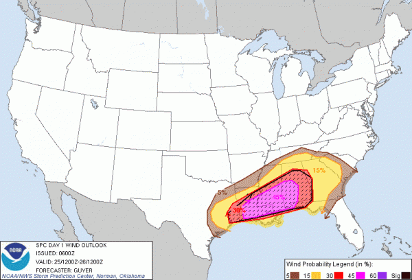
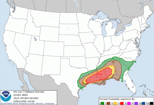
Below are the SPC risks…
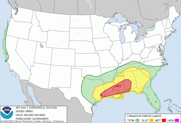
BOTTOM LINE: Our friends at the Storm Prediction Center is calling this a “dangerous” severe weather episode, and I totally agree. This is NOT to alarm anyone, but to simply let you know the threat level. This not hyperbole, but simply sharing information that is crucial. Like we do for every significant severe weather event.
For those asking “if this will be like April 27, 2011″… we choose not to answer that; please read this.
TRAVEL: We recommend that all travel be completed in West Alabama (west of I-65) by 3:00 p.m. today, and in East Alabama by 6:00 p.m. If you must travel past these times, please have a way of getting severe weather warnings. And, remember, many radio stations are not manned today and might not provide weather information. Use the ABC 33/40 smart phone apps to hear our audio.
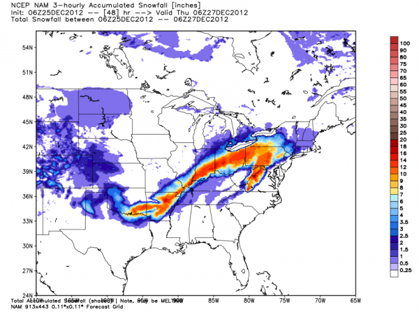
TO THE NORTHWEST: A big snow event will unfold northwest of the surface low. Below is the NAM snow projection through 48 hours, and a look at the various winter storm watches and warnings in effect.
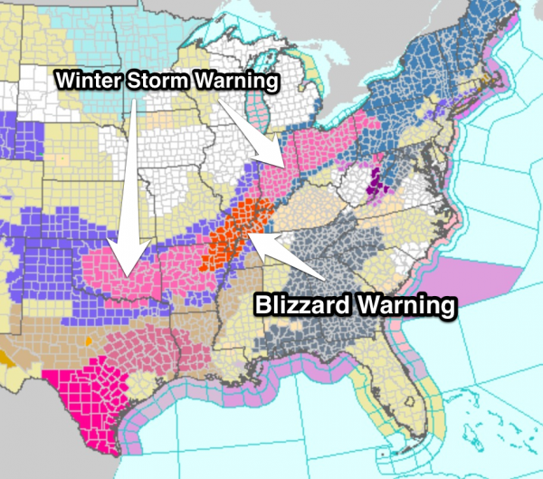
You sure don’t see blizzard warnings often on Christmas Day for parts of Tennessee, Arkansas, and Missouri!
We note that tomorrow in Alabama will be cold and raw with a risk of light snow or snow flurries over North Alabama, but no accumulation is expected. Some parts of North Alabama won’t get out of the 30s.
BE ABLE TO RECIVE WARNINGS: Never, never, never rely on an outdoor siren to let you know a tornado is coming. That is dangerous, and no telling how many Alabamians have been killed by this “siren mentality” over the years. They reach a limited number of people outdoors, and that is it. The baseline is having a NOAA Weather Radio in your home, properly programmed, and with fresh batteries in case of a power failure. Also, having a good smart phone warning app is even better. We recommend iMap WeatherRadio for iPhone and Android phones, and MyWarn for iPhone. Both will warn you ONLY if you are in a warning polygon (remember, warnings are not county based), you can program in fixed locations, and most importantly, you can watch live ABC 33/40 severe weather coverage within the app.
Yes, I am very active on social media, but remember on Facebook you won’t see all posts coming from me within your newsfeed unless you subscribe to my regular account (NOT friend request… subscribe) and choose to receive all updates from me. Quite frankly, Facebook is NOT a reliable way of getting severe weather warnings. Here are all my social media accounts….
KNOW WHERE TO GO: If you live in a mobile home and you are in a tornado warning polygon, you must leave. Remember, this is Christmas and many typical safe places will be closed. Think about it and be ready. And, if you live in a site built home, the safe place is a small room on the lowest floor, away from windows, and near the center of the home. Have readiness kit that includes helmets for everybody in the house, flashlights, extra batteries, shoes, medication, etc.
Here is a post I put together that shows good severe weather resources.
So… enjoy Christmas with your family this morning. But, by mid-afternoon, be sure you are near a place where you can get severe weather watches and warnings as they are issued. I will be at ABC 33/40 with Charles Daniel, and we will have a crew in the field for live streams today, including Brian Peters and John Brown. We have a full staff coming in today at ABC 33/40, and I am thankful for the sacrifices they have made, being away from their family, to support our weather team on this special day.
Category: Severe Weather
About the Author (Author Profile)
James Spann is one of the most recognized and trusted television meteorologists in the industry. He holds the AMS CCM designation and television seals from the AMS and NWA. He is a past winner of the Broadcast Meteorologist of the Year from both professional organizations.Subscribe
If you enjoyed this article, subscribe to receive more just like it.


