

Rain, Gusty Winds Push Northeast
Click image to enlarge
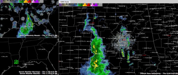
Thunderstorms that have been severe sporadically across Mississippi and Louisiana have weakened as they have moved into the more stable air over West Central Alabama this evening.
They are mainly affecting southern Pickens, Greene, Sumter and Choctaw Counties. They will move into Tuscaloosa, Hale and Marengo Counties in the next hour.
Other heavy showers have formed ahead of the main line, from southern Shelby and Coosa through Chilton and into Autauga and Lowndes Counties.
We can’t really call these showers thunderstorms, since they don’t seem to have much if any in the way of lightning. No lightning was observed at Meridian as they passed. Winds did gust to 35 mph though.
And winds gusted to 40 mph at Tupelo on the back side of the rain area. There was some tree damage in the Tupelo area.
LATE REPORT AT 6:24
NWS says there are reports of winds of 45 mph in Sumter County.
BACK TO ORIGINAL POST
Interestingly, the winds will be mainly on the back side of the rain area, unlike our typical storms that feature the wind on the front side.
So, rain and some gusty winds will be the only impact. There is no threat of severe weather.
Category: Alabama's Weather, Severe Weather
About the Author (Author Profile)
Bill Murray is the President of The Weather Factory. He is the site's official weather historian and a weekend forecaster. He also anchors the site's severe weather coverage. Bill Murray is the proud holder of National Weather Association Digital Seal #0001 @wxhistorianSubscribe
If you enjoyed this article, subscribe to receive more just like it.


