

Freezing Rain Advisory Late Tonight/Early Tomorrow
An all new edition of the ABC 33/40 Weather Xtreme video is available in the player on the right sidebar of the blog. You can subscribe to the Weather Xtreme video on iTunes by clicking here.
ON THE MAPS: A cold front is moving into North Alabama this morning, being pushed southward by a big 1045 mb high over northern Minnesota, where Crane Lake reports 36 below zero as I write this. This front will push down toward the U.S. 80 corridor by midday, setting up a huge thermal contrast across our state today.
Over North Alabama, temperatures will hover in the 40s, maybe even dropping a few degrees during the day. But, south of the front over the southern counties of the state, it will be a mild day with highs in the 60s. There might be a touch of light rain or a few sprinkles around, but the day should be generally dry despite the front.
ICING ISSUES LATE TONIGHT EARLY TOMORROW: With a shallow layer of cold air in place, and a batch of precipitation moving in from the west, the stage is set for a little freezing rain late tonight and early tomorrow over parts of North and East Alabama. Freezing rain is not sleet (ice pellets), it is liquid that falls when surface temperatures are at or below freezing. Accordingly, exposed objects can get a coating of ice.
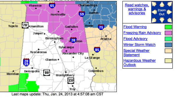
The NWS offices in Huntsville and Birmingham have issued a “freezing rain advisory” for these Alabama counties…
Lauderdale, Colbert, Franklin, Lawrence, Limestone, Morgan, Cullman, Madison, Jackson, Marshall, DeKalb, Blount, Etowah, Cherokee, St. Clair, Calhoun, Cleburne, Talladega, Clay, and Randolph.
This includes cities like Gadsden, Anniston, Fort Payne, Oneonta, Pell City, Sylacauga, Ashland, Lineville, Roanoke, and Heflin. It does not include the Birmingham metro or Tuscaloosa.
Here are some important points about this event…
*The main issue within the advisory is the potential for bridge icing. You will also see a little ice accumulating in trees and other exposed objects, but the precipitation is expected to be light, not enough for power outages. If you are driving across North or East Alabama late tonight or early tomorrow, just be aware that there could be some icy patches on bridges and overpasses.
*The main window for this light freezing rain is from about 11:00 p.m. tonight through 7:00 a.m. tomorrow. Temperatures should warm above freezing easily by mid-morning in the advisory area; the exception could be a few colder pockets across Jackson and DeKalb Counties of far Northeast Alabama, where a few icy spots could linger through midday.
*There is NO snow involved; the cold air is very shallow.
See the Weather Xtreme video for the graphics, maps, and more details. Otherwise… tomorrow will be cloudy and wet day with periods of rain and a high in the low 50s.
THE ALABAMA WEEKEND: Saturday and Sunday will be dry and cool with seasonal temperatures; highs in the 50s, and lows at or a little below freezing both mornings. The sky will be partly sunny.
SEVERE WEATHER NEXT WEEK? Our active weather continues. Temperatures warm into the 60s early next week with increasing moisture levels as a major upper trough begins to lift out of the Southwest U.S. SPC has much of Arkansas and the Mid-South in a severe weather risk on Tuesday, and we could very well have a similar issue here in Alabama Wednesday with very unstable air in place and some decent dynamic support. But, there is simply no way of resolving details of this system so far in advance. See the Weather Xtreme video for the details and maps.
WEATHER BRAINS: Don’t forget you can listen to our weekly 90 minute netcast anytime on the web, or on iTunes. This is the show all about weather featuring many familiar voices, including our meteorologists here at ABC 33/40.
CONNECT: You can find me on all of the major social networks…
I will be doing a weather program today at Bluff Park Elementary School in Hoover… look for the next Weather Xtreme video here by 4:00 this afternoon… enjoy the day!
Category: Alabama's Weather
About the Author (Author Profile)
James Spann is one of the most recognized and trusted television meteorologists in the industry. He holds the AMS CCM designation and television seals from the AMS and NWA. He is a past winner of the Broadcast Meteorologist of the Year from both professional organizations.Subscribe
If you enjoyed this article, subscribe to receive more just like it.


