

Battle Of The Air Masses
An all new edition of the ABC 33/40 Weather Xtreme video is available in the player on the right sidebar of the blog. You can subscribe to the Weather Xtreme video on iTunes by clicking here.
THIS AFTERNOON: Temperatures across Alabama are all over the board as three air masses are battling for dominance.
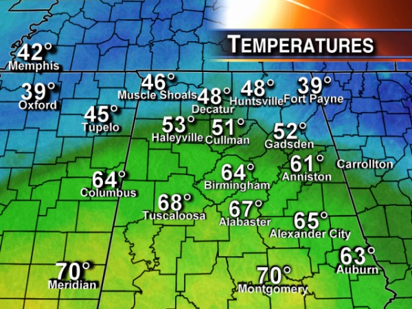
AIRMASS ONE: The wedge front remains over northeast Alabama; cold air damming has parts of Jackson, DeKalb, and Cherokee Counties in the upper 30s. Fort Payne reports 39 degrees at mid-afternoon.
AIRMASS TWO: A warm nose of air moved northward today through Central Alabama; Montgomery has soared to 70 degrees at 2:00. Tuscaloosa, Birmingham, and Anniston are in the 60s.
AIRMASS THREE: Colder air in the wake of a cold front is moving into Northwest Alabama, where Muscle Shoals is at 46 degrees at 2:00.
For North-Central Alabama, air mass three will slip in here tonight, and it should push temperatures down into the 30s by daybreak tomorrow. So far, rain has been pretty much a no-show along the front, but a few patches of light rain will remain possible this evening. But, needless to say, rain amounts will be very light and spotty.
OUR WEEKEND: The weekend looks dry with a mix of sun and clouds tomorrow and Sunday. We reach the upper 50s tomorrow, followed by low 60s Sunday.
NEXT WEEK: Get ready for a spring preview. We reach the mid 60s Monday, and the GFS continues to suggest we reach the 70s on Tuesday and Wednesday, not too far from record levels for late January. Any showers on Monday and Tuesday will be few and far between as the dynamic support remains well to the west.
Strong storms are a very real possibility on Wednesday as a major upper trough lifts out of the Southwest U.S. The GFS and the ECMWF are actually in pretty good agreement; if we deal with severe weather it looks like the main risk will come from strong straight line winds along a squall line ahead of the cold front Wednesday evening.
Then, much colder air invades the Deep South Thursday with highs dropping into the 40s. See the Weather Xtreme video for details and maps.
WEATHER BRAINS: Don’t forget you can listen to our weekly 90 minute netcast anytime on the web, or on iTunes. This is the show all about weather featuring many familiar voices, including our meteorologists here at ABC 33/40.
CONNECT: You can find me on all of the major social networks…
I had a great time today visiting with the first graders at Crestline Elementary School in Mountain Brook; see them on the Pepsi KIDCAM today at 6:00 on ABC 33/40 News….
Brian Peters will have the video updates tomorrow and Sunday; my next Weather Xtreme video will be posted early Monday morning by 7:00 a.m. Enjoy the weekend!
Category: Alabama's Weather
About the Author (Author Profile)
James Spann is one of the most recognized and trusted television meteorologists in the industry. He holds the AMS CCM designation and television seals from the AMS and NWA. He is a past winner of the Broadcast Meteorologist of the Year from both professional organizations.Subscribe
If you enjoyed this article, subscribe to receive more just like it.


