

Tonight into Tomorrow
A few clouds and a few sprinkles have popped up on the radar tonight. Nothing of significance.
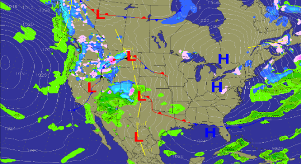
As we look at the surface map heading through the overnight hours, high pressure will be settling into Eastern Ohio. Luckily, we are on the west side of the high which means our winds will be switching from the northeast overnight and will become more easterly and then southerly over the next 24 hours. That will keep the bitterly cold temps associated with the high from affecting us. With our winds becoming southerly, we can expect warmer temperatures and more moist air to move in especially once the front along the Gulf Coast begins to lift north. This will allow for a substantial warm up ahead for the Southeast. Tomorrow will be a mix of sun and clouds as high pressure will be battling an increase in moisture. The warmer air mass will begin to win the battle and clouds will be increasing in coverage by late tomorrow evening. Sunday should be an overall very nice day. We will start off in the upper 30s and lower 40s in the morning and afternoon highs will head towards the 60s.
With such a warm moist air mass setting in the next few days and a strong cold front diving in to the west, that will begin to head east, a clashing of such different air masses means we will have to keep our eye on the forecast as it looks as though a significant storm system will impact us in the middle of the week with a chance for some strong to possibly severe storms.
Category: Alabama's Weather
About the Author (Author Profile)
Macon, Georgia Television Chief Meteorologist, Birmingham native, and long time Contributor on AlabamaWX. Stormchaser. I did not choose Weather, it chose Me. College Football Fanatic. @Ryan_StinnetSubscribe
If you enjoyed this article, subscribe to receive more just like it.


