

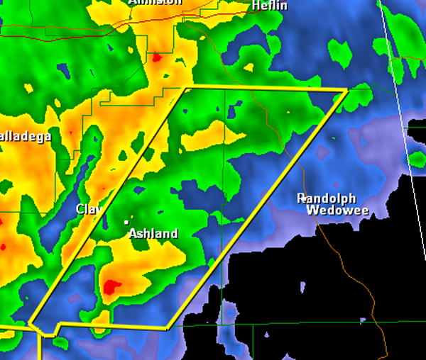
Severe Thunderstorm Warning : Clay/Randolph until 11:15 AM

Rotating thunderstorm south of Ashland in Clay County is moving rapidly north northeast. It will pass near or just east of Lineville between 10:45 and 11 o’clock.
Be in a substantial structure as this storm approaches you. It could produce damaging winds in excess of 60 mph.
With the rotation on radar, it could also produce a tornado.
The earlier tornado warned storm in Calhoun and Cleburne Counties did produce a tornado on the ground near Calhoun GA.
There is also rotation on a storm that has a severe thunderstorm warning on it for Elmore County. The rotation is near Wetumpka. Wouldn’t be surprised to see a tornado warning shortly.
THE NATIONAL WEATHER SERVICE IN BIRMINGHAM HAS ISSUED A
* SEVERE THUNDERSTORM WARNING FOR…
EASTERN CLAY COUNTY IN EAST CENTRAL ALABAMA…
NORTHWESTERN RANDOLPH COUNTY IN EAST CENTRAL ALABAMA…
* UNTIL 1115 AM CST
* AT 1031 AM CST…THE NATIONAL WEATHER SERVICE INDICATED A SEVERE
THUNDERSTORM CAPABLE OF PRODUCING DAMAGING WINDS IN EXCESS OF 60
MPH. THIS STORM WAS LOCATED 5 MILES NORTHWEST OF GOLDVILLE…OR 11
MILES EAST OF GOODWATER…AND MOVING NORTHEAST AT 60 MPH.
* LOCATIONS IMPACTED INCLUDE…
ASHLAND…LINEVILLE…LAKE WEDOWEE…BARFIELD…DELTA…FOSTERS
CROSS ROADS…MORRISON CROSS ROADS AND MELLOW VALLEY.
WINDS OF 60 TO 70 MPH WILL BREAK LARGE TREE LIMBS AND CAUSE SOME
DAMAGE…ESPECIALLY TO SMALLER STRUCTURES.
PRECAUTIONARY/PREPAREDNESS ACTIONS…
A TORNADO WATCH REMAINS IN EFFECT FOR THE WARNED AREA. TORNADOES CAN
DEVELOP QUICKLY FROM SEVERE THUNDERSTORMS. ALTHOUGH NOT IMMEDIATELY
LIKELY…IF A TORNADO IS SPOTTED…ACT QUICKLY AND MOVE TO A PLACE OF
SAFETY INSIDE A STURDY STRUCTURE…SUCH AS A BASEMENT OR SMALL
INTERIOR ROOM.
Category: Alabama's Weather, Severe Weather
About the Author (Author Profile)
Subscribe
If you enjoyed this article, subscribe to receive more just like it.


