

Elevated Storms into Alabama Already
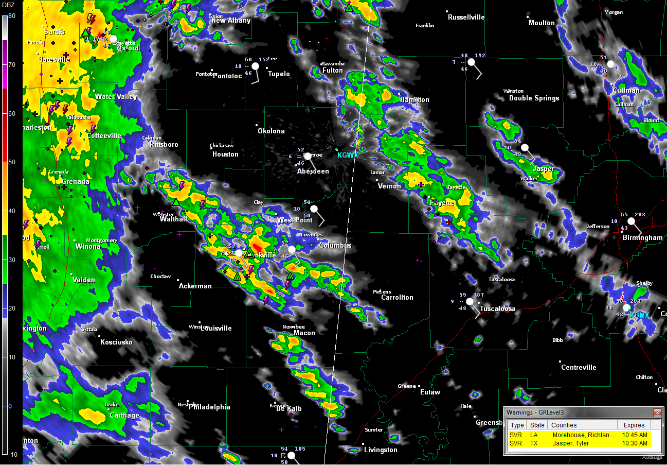
Showers and even some elevated thunderstorms are increasing across much of Mississippi into northwestern Alabama this morning ahead of a warm front in a conveyor belt of warm, moist air being shunted northward out of the Gulf of Mexico by strong winds in the lower atmosphere.
We call them elevated, because the instability they are feeding on is aloft, but near the ground. They generally don’t become severe, but do produce loud thunder, heavy rain and gusty winds.
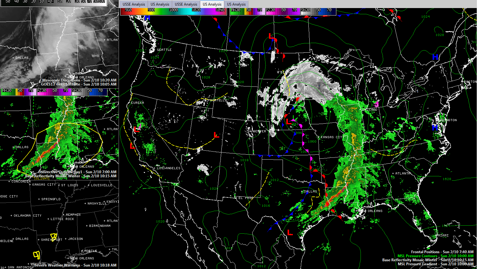
The surface low and its associated upper low is over southern Nebraska this morning. The upper system is weakening, as is the surface feature. But it is still strong enough to cause very strong winds. You can hear them roaring outside your window on this Sunday morning.
Heavy snow is falling north of the low over eastern North Dakota and southern Minnesota, changing over to a long line of rain and storms that extends from west of Chicago through southeastern Missouri into Arkansas, northern Louisiana and eastern Texas. The further south you go, the more instability gets involved, and we have the threat of severe weather.
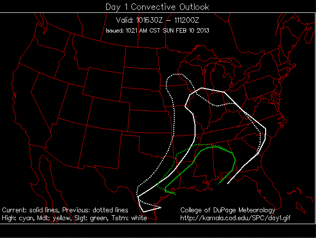
The instability is surface based, and severe thunderstorm warnings have been issued for parts of Texas and Louisiana. The SPC has an area bounded by a line from Houston to Shreveport to Little Rock to Memphis to east of Birmingham to Columbus GA to Pensacola included in their standard severe weather forecast, a “slight” risk.
The new outlook just came out. This College of DuPage graphic shows how the western edge was shifted east to account for the progress of the cold front.
The further southwest you go, the instability becomes surface based and some of the storms have already been severe. A tornado watch is in effect for extreme southern Arkansas, much of central Louisiana and parts of eastern Texas. There are currently two severe thunderstorm warnings in eastern Texas and northeastern Louisiana.
Our warm front lies along the border between Texas and Louisiana this morning. This warm front will lift northeastward through the day, reaching into Alabama by this afternoon. It will be preceded by an increasing mass of showers and storms. There will be lots of heavy rain and some lightning and thunder with this activity, and we can’t rule out a couple of severe thunderstorm warnings, but heavy rain, not severe weather will be the main threat as it moves through between 1 and 6 p.m.
We will be keeping an eye on the weather back to the west over Louisiana this afternoon as well, as a few supercell thunderstorms form in the unstable airmass that will build there. There will be a better chance of tornadoes from Alexandria LA to Jackson MS back down to New Orleans.
After 6 p.m. here in Central Alabama, we will be in the warm sector as well, but our instabilities won’t be anything like those to the west. In fact, we will have a hard generating enough instability to build any storms ahead of the squall line that will form to the west and sweep through our area late tonight. There could be a couple of storms ahead of the main line in western counties as early as 6-8 p.m. They could spin up a tornado of two, so we will be watching them, but the main tornado threat should remain to the west over Mississippi.
The main line of storms should be into western Alabama by 7-9 p.m. Those storms will have the potential to produce damaging winds and a few spin up tornadoes as it pushes eastward. This line should be to Tuscaloosa-Jasper between 9-10 p.m. and Birmingham/Gadsden area by 11 p.m. – midnight on into eastern Alabama after that.
But the good news is that as the upper/surface lows weaken and move off to the northeast, the shear will weaken and the storms should as well the deeper we go into the evening.
The bad news is that precipitable water values are going to be over 1.50 inches over Central Alabama tonight. This is in the 99th percentile for this time of year! Rainfall will be heavy. By tomorrow morning, rainfall amounts will be between 1.5-2.5 inches within about 75 miles of the I-59 corridor, tapering to about an inch over Northwest and Southeast Alabama.
More rain is ahead as additional rounds of rain will come in Monday afternoon and Tuesday afternoon. BY Wednesday morning, amounts will be around 3 inches in the I-59 corridor, increasing to 4-5 inches over South Central Alabama.
SO BOTTOM LINE
…Windy afternoon
…Increasing showers and storms this afternoon from the west through the afternoon (low chance of severe)
…Evening storms could become severe, with slight chance of tornadoes over West Central Alabama.
…A squall line moving through the state between 8 p.m. and 2 a.m. with threat of damaging winds, isolated tornadoes.
…Keep flooding threat in mind as well.
CALL TO ACTION
…Review your personal severe weather safety plan in the context of where you will be this evening and tonight.
…Have a reliable way of receiving severe weather warnings. A NOAA Weatheradio properly set to alert you, a smartphone app like MyWARN or iMAP Weatheradio, or a notification system like WeatherCall for your home phone.
…Be ready to take immediate action if a warning is issued for your location.
…Check the blog frequently for updates. We will be in the Weather Center through early Monday. All warnings will posted as well.
…If tornado warnings are issued, live coverage will be wall to wall on ABC3340 of course.
Category: Alabama's Weather, Severe Weather
About the Author (Author Profile)
Bill Murray is the President of The Weather Factory. He is the site's official weather historian and a weekend forecaster. He also anchors the site's severe weather coverage. Bill Murray is the proud holder of National Weather Association Digital Seal #0001 @wxhistorianSubscribe
If you enjoyed this article, subscribe to receive more just like it.


