

Strong Storms Approaching Alabama Border
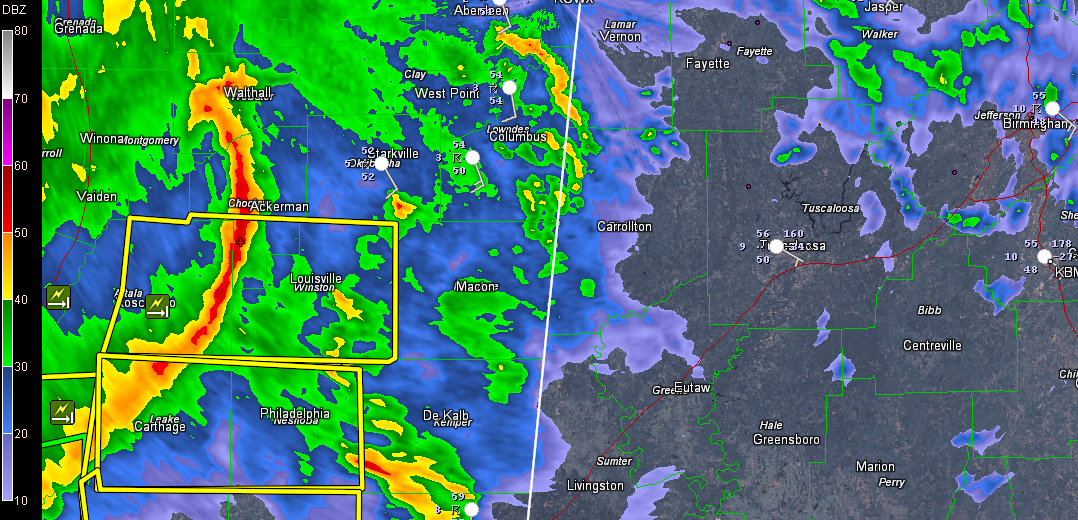
A complex of storms moving across Central Mississippi evolved into a bow echo that has produced a few reports of damage. It has prompted a series of severe thunderstorm warnings. You can pick it out clearly on this radar image from the Columbus Doppler radar. There is a pretty strong little upper level disturbance with a bit of surface low reflection approaching Columbus MS it appears.
The NWS in Jackson just issued a new severe thunderstorm warning for Newton and Scott Counties for areas along I-20 west of Meridian.
Trees were reported down in Yazoo County and there was a possible tornado in northwestern Warren County in western Mississippi with the tops of trees broken off. Numerous trees and power lines were reported in Warren County, which is the county where Vicksburg is located.
The bow echo is approaching Starkville now, moving east northeast at 50 mph. At that rate, it could be into Pickens and Sumter counties around 1:15 p.m.
It appears to be weakening a bit, but there could be warnings as it gets into Alabama. Winds are estimated to be 60-70 mph in the main part of the line over Choctaw and Winston Counties in Central Mississippi.
Very heavy rain is falling. Vicksburg picked up one inch of rain in 30 minutes. The southern part of the line of storms is stalling across the Jackson Metro and flash flood warnings have been issued.
There are elevated thunderstorms across parts of Central Alabama with occasional lightning and booming thunder. They are not severe at this time.
Category: Alabama's Weather, Severe Weather
About the Author (Author Profile)
Bill Murray is the President of The Weather Factory. He is the site's official weather historian and a weekend forecaster. He also anchors the site's severe weather coverage. Bill Murray is the proud holder of National Weather Association Digital Seal #0001 @wxhistorianSubscribe
If you enjoyed this article, subscribe to receive more just like it.


