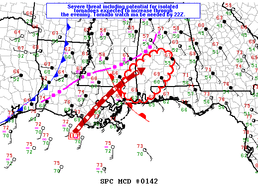
New Tornado Watch for Southwest/South Central Alabama Soon
The SPC says that a new tornado watch will be required before 4 p.m. for part of South Central and Southwest Alabama as well as more of southern Mississippi.
It will probably include an area generally bounded by Butler to Marion to Billingsley to Montgomery to Brewton.
Here is the text of the mesoscale discussion:
MESOSCALE DISCUSSION 0142
NWS STORM PREDICTION CENTER NORMAN OK
0239 PM CST SUN FEB 10 2013
AREAS AFFECTED…EXTREME SERN MS THROUGH SWRN AND SCNTRL AL
CONCERNING…SEVERE POTENTIAL…WATCH LIKELY
VALID 102039Z – 102145Z
PROBABILITY OF WATCH ISSUANCE…80 PERCENT
SUMMARY…THE THREAT FOR A FEW TORNADOES AND DAMAGING WIND IS
EXPECTED TO INCREASE THROUGH THE EARLY EVENING FROM EXTREME SERN MS
INTO SWRN AND SCNTRL AL. A WW WILL LIKELY BE NEEDED BEFORE 22Z.
DISCUSSION…A WARM FRONT EXTENDS FROM THE BOOT HEEL OF MS NWWD INTO
THE CNTRL PORTIONS OF SRN MS. NUMEROUS STORMS ARE DEVELOPING ACROSS
SWRN AL WHERE A 50 KT SSWLY LLJ IS AUGMENTING ISENTROPIC ASCENT NE
OF THIS BOUNDARY. THESE INITIAL STORMS ARE LIKELY ELEVATED ABOVE A
SHALLOW NEAR SURFACE STABLE LAYER THAT RESIDES NORTH OF THE WARM
FRONT. HOWEVER…RICHER GULF MOISTURE WITH AT LEAST MID 60S
DEWPOINTS WILL CONTINUE ADVECTING NEWD ALONG THE LLJ
AXIS…CONTRIBUTING TO BOUNDARY LAYER DESTABILIZATION INTO THE
EVENING. LARGE LOW LEVEL HODOGRAPHS AND STRONG EFFECTIVE SHEAR WILL
PROMOTE A THREAT OF SUPERCELLS AND BOWING SEGMENTS WITH TORNADO
THREAT LIKELY TO INCREASE LATER THIS AFTERNOON INTO THE EVENING WITH
THE EROSION OF THE NEAR SFC STABLE LAYER.
Category: Alabama's Weather, Severe Weather


