

Soaking Rain Continues
**No afternoon Weather Xtreme video today… getting ready for our Storm Alert 2013 show tonight in Jasper at the CHS building; show starts at 6:30**
WET, WET, WET: Heavy rain is moving through West Alabama as I write this… the heavier rain is moving into the Birmingham metro at mid-afternoon.
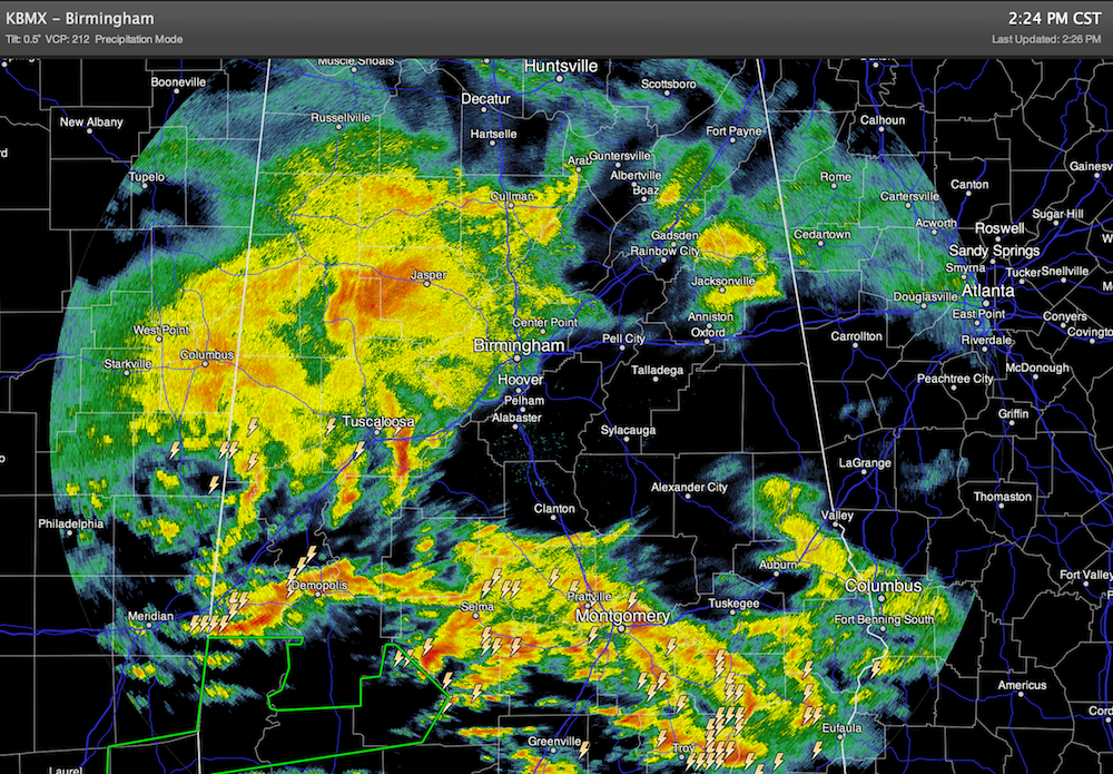
A flash flood watch remains in effect for Tuscaloosa, Birmingham, Anniston, and points south through tonight; an additional one to two inches of rain is possible through midnight, with flooding very possible, especially in low areas.
Temperatures are very chilly, and colder than forecast around here. Birmingham reports only 45 degrees at 2:00 with a steady, miserable rain.
We note that SPC is about to issue a tornado watch for parts of South and Southwest Alabama…
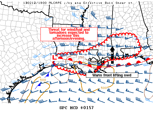
The air is unstable down that way, and a few storms could produce a tornado through tonight; all of the Mardi Gras party folks need to pay attention to the weather. We do not expect any severe weather over the northern half of Alabama; the air is too cool and stable, although thunder and lighting is certainly possible.
TOMORROW: Rain will end early in the day, but the clouds should linger with a high in the 50s.
BRIGHTER WEATHER: We expect a good supply of sunshine tomorrow and Friday, with a high in the 57 to 61 degree range both days. But, north of Birmingham, Friday afternoon will be cooler as the first of two fronts will pass through.
FRIGID SATURDAY: A quick hitting shot of cold, Arctic air blows in here Saturday. Is is very doubtful we get out of the 30s with an icy north wind. The GFS looks pretty dry, but the ECMWF hints at snow flurries or snow showers across much of the state Saturday with a deep, cold upper trough passing overhead; we will continue to mention that in our forecast. Accumulation doesn’t seem likely with very limited moisture profiles.
Sunday morning will be very cold; most places will wind up in the 20 to 25 degree range; colder valleys and protected areas should reach the teens. Then, a warming trend begins Sunday afternoon as we rise into the low 50s.
NEXT WEEK: Rain and storms are likely Tuesday with a fairly dynamic weather system; we will have to see if the atmosphere can recover enough for strong to severe storms. Just a possibility for now… we will keep an eye on this as it gets closer.
STORM ALERT 2013 IN JASPER TONIGHT: Our annual severe weather awareness tour across Alabama continues through February. We will share lessons learned after the April 27, 2011 generational tornado event, along with other amazing weather stories. Learn how to keep your family safe during severe weather, and have a chance to win some cool prizes as well. Here are the remaining Storm Alert tour dates…
TONIGHT Jasper – CHS Community Building
February 21 Clanton – Jeff State Performing Arts Center
February 26 Ohatchee – Ohatchee High School
February 28 Clay – Clay/Chalkville High School
All shows begin at 6:30… be sure and get there early to get a good seat.
WEATHER BRAINS: Don’t forget you can listen to our weekly 90 minute netcast anytime on the web, or on iTunes. This is the show all about weather featuring many familiar voices, including our meteorologists here at ABC 33/40. Scroll down for the show notes on this week’s new episode.
CONNECT: You can find me on all of the major social networks…
Hope to see many of you tonight in Jasper at Storm Alert 2013… the next Weather Xtreme video will be posted here early tomorrow morning, by 7 a.m….
Category: Alabama's Weather
About the Author (Author Profile)
James Spann is one of the most recognized and trusted television meteorologists in the industry. He holds the AMS CCM designation and television seals from the AMS and NWA. He is a past winner of the Broadcast Meteorologist of the Year from both professional organizations.Subscribe
If you enjoyed this article, subscribe to receive more just like it.


