

Midday Update
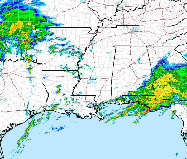
A quick check of the radar has us focused on two areas of showers and thunderstorms late this morning. We have had several severe thunderstorm warning in south Alabama and Georgia and Northern Florida this morning with reports of large hail in the area. We are seeing a break in the activity across Alabama and Mississippi, but are beginning to see some showers and thunderstorms develop in Arkansas, Louisiana and along the front in East Texas. We should see a tornado watch issued in the near future along and ahead of the cold front. You can see a thin line of convection trying to develop from near Houston north into southeastern Oklahoma. As the front continues to push east into a warm unstable air mass and provide the additional lifting needed, we will see more thunderstorms develop. The most severe weather should stay confined to the Gulf Coast as the cold front approaches Alabama. The warm front is not expected to lift very far north from the coast and will be what prevents widespread severe weather across Central Alabama.
A look at the latest outlook from the SPC this morning, continues to show the greatest threat of severe weather remaining to our South. For Alabama the risk threat crosses the state from near Butler in Choctaw County east to southern Russell County. The current risk area remains just south of Selma, Montgomery and Columbus, GA. Severe threats are hail and damaging winds early in the day. As the warm front lifts north we are looking for more of a chance for some tornadoes especially along the Interstate 10 corridor. Remember that you don’t have to be in a risk or even a watch to get severe weather. Most of the time if you pay close attention to the wording, it will say in or near the risk or watch area. Just keep that in mind, as there could be an isolated severe storm not in the risk area.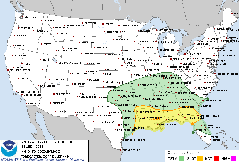
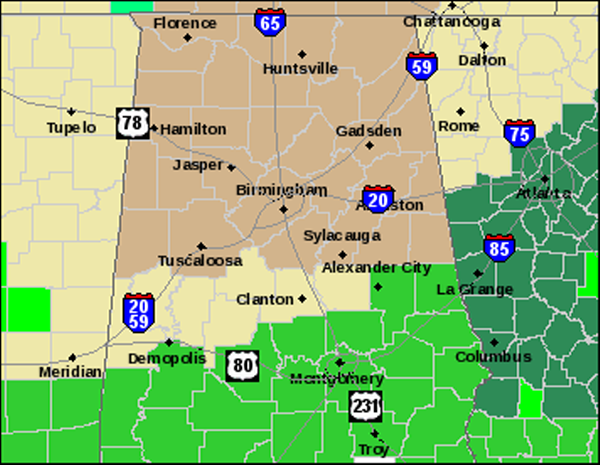
Heavy rains continue to fall on saturated grounds and flooding looks to be the greatest concern with this system, especially the farther south you go. It has rained most of the weekend along the Gulf Coast and any additional rain will only make the flooding conditions worse. All the counties in green are under a flash flood watch through tonight. An additional 2-4 inches of rain are expected with this system in those areas. I would not be surprise to see some flood advisories across North Central Alabama before all is said and done with this system. One more thing to note, all the counties in brown are under a wind advisory that will go into effect this evening at 6PM. As the could front approaches, surface winds will be increasing and could be sustained at 20-25 mph with gust over 35mph. All this wind and saturated grounds could cause trees to uproot easily and cause power outages.
Category: Alabama's Weather
About the Author (Author Profile)
Macon, Georgia Television Chief Meteorologist, Birmingham native, and long time Contributor on AlabamaWX. Stormchaser. I did not choose Weather, it chose Me. College Football Fanatic. @Ryan_StinnetSubscribe
If you enjoyed this article, subscribe to receive more just like it.


