

Severe Thunderstorm Warning for Lowndes County til 5:15 p.m.

LATE REPORT
Quarter sized hail covering the ground at Collirene in Lowndes County. Completely covering the ground. The hail core will pass near Moss before 5 p.m. and near Haynesville shortly after 5. Be prepared for 2 inch hail!.
ORIGINAL POST
Our storm which has a high potential for large hail is entering Lowndes County now, and will pass near Haynesville and Lowndesboro after passing near or north of moss and Gordonville.
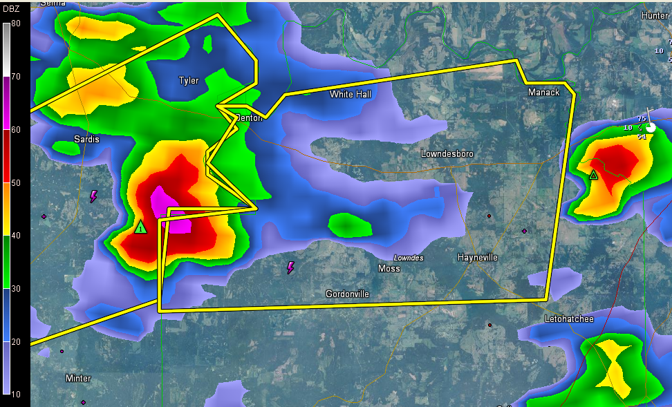
THE NATIONAL WEATHER SERVICE IN BIRMINGHAM HAS ISSUED A
* SEVERE THUNDERSTORM WARNING FOR…
NORTHERN LOWNDES COUNTY IN SOUTH CENTRAL ALABAMA…
* UNTIL 515 PM CDT
* AT 426 PM CDT…THE NATIONAL WEATHER SERVICE INDICATED A SEVERE
THUNDERSTORM CAPABLE OF PRODUCING QUARTER SIZE HAIL. THIS STORM
WAS LOCATED 6 MILES EAST OF BELKNAP…OR 13 MILES SOUTHEAST OF
SELMONT-WEST SELMONT…AND MOVING EAST AT 25 MPH.
* LOCATIONS IMPACTED INCLUDE…
MOSSES…HAYNEVILLE…BENTON…GORDONVILLE…WHITE HALL…
LOWNDESBORO…COLLIRENE AND MANACK.
Category: Alabama's Weather, Severe Weather
About the Author (Author Profile)
Subscribe
If you enjoyed this article, subscribe to receive more just like it.


