

Severe Thunderstorm Warning Marion/Winston until 6PM

UPDATE: The NWS is reporting some damage reports around the Bear Creek community in Marion County. Reports of tree and power line damage around Virginia Avenue.
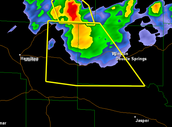
A strong thunderstorm was moving south out of Franklin County into Marion and Winston Counties. This storm will be impacting highways 243 and 278. The main threat with this storm is damaging winds and some large hail may be possible as well. It will continue to move south and impact areas in and around Haleyville, Natural Bridge and Double Springs.
THE NATIONAL WEATHER SERVICE IN BIRMINGHAM HAS ISSUED A
* SEVERE THUNDERSTORM WARNING FOR…
EASTERN MARION COUNTY IN NORTHWEST ALABAMA…
WESTERN WINSTON COUNTY IN NORTHWEST ALABAMA…
* UNTIL 600 PM CDT
* AT 502 PM CDT…THE NATIONAL WEATHER SERVICE INDICATED A SEVERE
THUNDERSTORM CAPABLE OF PRODUCING QUARTER SIZE HAIL…AND DAMAGING
WINDS IN EXCESS OF 60 MPH. THIS STORM WAS LOCATED 9 MILES NORTH OF
HALEYVILLE…AND MOVING SOUTHEAST AT 20 MPH.
* LOCATIONS IMPACTED INCLUDE…
HALEYVILLE…LYNN…BRINN…NEEDMORE…LAKE BUTTAHATCHEE…
ASHRIDGE…BRILLIANT AND WINSTON FREE STATE BARN.
PRECAUTIONARY/PREPAREDNESS ACTIONS…
FOR YOUR PROTECTION…MOVE TO AN INTERIOR ROOM ON THE LOWEST FLOOR OF
YOUR HOME OR BUSINESS.
Category: Alabama's Weather, Severe Weather
About the Author (Author Profile)
Subscribe
If you enjoyed this article, subscribe to receive more just like it.


