

Strong Storms Dropping South
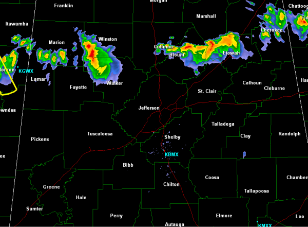
A broken line of storms continues to drop south across Central Alabama. There was one severe thunderstorm warning for Marion and Winston Counties, with sporadic wind damage, but since then the storms have weakened a bit. Currently, none of these storms are severe, but they are strong. They are capable of producing gusty winds, hail, frequent lightning and torrential rains.
The most intense storms are from Aberdeen, Mississippi to near Carbon Hill and Jasper in Walker County. Farther east, areas in Blount and Etowah Counties are seeing stormy conditions. Areas in and around Oneonta, Steele, Gadsden and Ranibow City are being impacted. Storms will be approaching the Interstate 20 corridor over the next hours or so. These storms will continue to push south over the next few hours and could briefly reach severe limits.
Category: Alabama's Weather
About the Author (Author Profile)
Macon, Georgia Television Chief Meteorologist, Birmingham native, and long time Contributor on AlabamaWX. Stormchaser. I did not choose Weather, it chose Me. College Football Fanatic. @Ryan_StinnetSubscribe
If you enjoyed this article, subscribe to receive more just like it.


