

Storms Northeast and Southwest
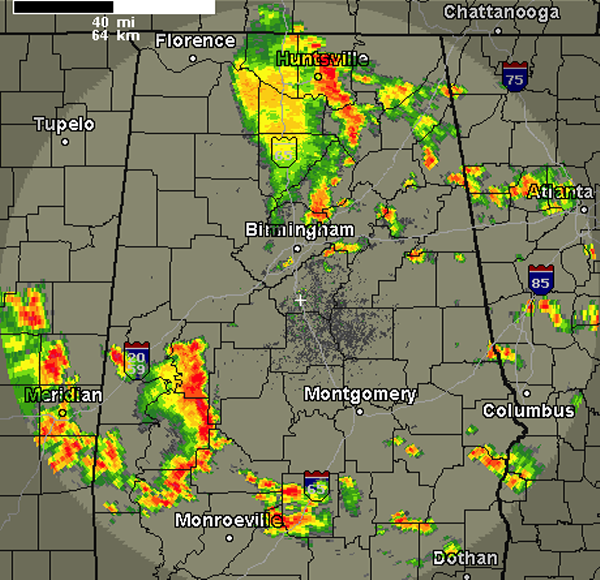
A quick radar check the afternoon shows numerous showers and some strong thunderstorms across Central Alabama. The most intense storms are currently across our southwestern counties and are impacting areas from near Moundville down through Greensboro and Faunsdale and will soon be impacting areas around Uniontown, Marion, Selma and Brent. Currently, none of these storms are currently severe, but they are very intense. They are producing dangerous and frequent lightning, tremendous amounts of rain and some gusty winds. These storms will continue to push east and at any time could pulse up in intensity and reach severe limits briefly. Greatest severe weather threats will be damaging winds and hail. There are some intense storms along the Interstate 65 corridor from just north of Birmingham up to Huntsville and over portions of northeast Alabama.
Through the rest of the afternoon, we expect additional storms to develop as a very unstable air mass is in place across the state. There is just enough uplift and ample fuel for convective activity that showers and thunderstorms can rapidly develop. More showers and storms are developing across Mississippi as well and will be working their way into Alabama later this afternoon. Storm will once again last into the overnight hours and we can expect another active day for storms on Tuesday as well. We are monitoring many areas for a flash flooding threat as these storms are producing tremendous amounts of rainfall.
Category: Alabama's Weather
About the Author (Author Profile)
Macon, Georgia Television Chief Meteorologist, Birmingham native, and long time Contributor on AlabamaWX. Stormchaser. I did not choose Weather, it chose Me. College Football Fanatic. @Ryan_StinnetSubscribe
If you enjoyed this article, subscribe to receive more just like it.


