

Showers and Storms on the Increase
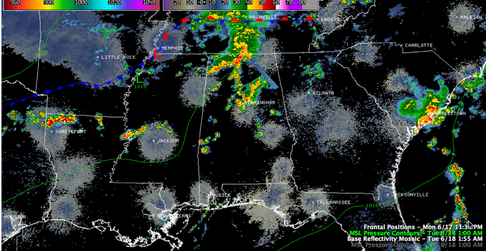
As expected, showers and storms have increased early this morning across Central Alabama.
Just before 2 a.m., they are heavy in the Birmingham Metro area, extending across much of Jefferson County over western St. Clair, eastern Blount and into western Etowah County.
They are not severe and are not expected to become severe. But they have a good amount of lightning and loud shaking thunder, as well as very heavy rain. 0.54 inches fell in 30 minutes at the Birmingham Airport between 1:13 and 1:43 a.m. and it was still raining heavily.
Other showers were forming over Lamar, Fayette and Marion Counties as well as over Greene and Tuscaloosa Counties. The activity is ahead of a surface low near Memphis and a cold front that trails back to near Dallas. This front will make its way into Alabama later today and push south of Birmingham by this evening. This will allow drier air to spread into the state and will give us drier weather for Wednesday and beyond. But there will be additional showers and storms through the early morning hours and likely another round during the day just ahead of the front.
Category: Alabama's Weather
About the Author (Author Profile)
Bill Murray is the President of The Weather Factory. He is the site's official weather historian and a weekend forecaster. He also anchors the site's severe weather coverage. Bill Murray is the proud holder of National Weather Association Digital Seal #0001 @wxhistorianSubscribe
If you enjoyed this article, subscribe to receive more just like it.


