

A Noonday Update
As we sail into afternoon here in Central Alabama, here is a quick look at the Alabama weather situation.
Yesterday’s cold front lies across southeastern Alabama with a surface low tracking along it southwest of Atlanta. The front isn’t going to go much further to the south though. Another weak surface low was east of New Orleans, pushing to the east northeast slowly as well. The front will have a hard time making it to the coast. That’s a tough nut to crack in the summer in the South.
The front was triggering widespread showers and storms from the Northeast U.S. across eastern North Carolina and into northern Florida. Severe severe thunderstorm and flash flood warnings have been issued, including a couple in northeastern Florida. There is even a tornado warning right now west of Wilmington NC.
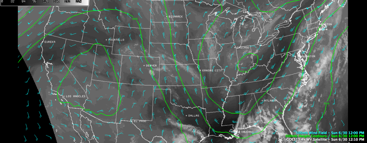
The upper air charts are dominated by an impressive upper level high centered near Las Vegas, with an equally impressive trough covering the east third of the nation, anchored by a big upper low near Indianapolis. We are feeling the influence of this trough and will for the next couple of days. It is responsible for the front to our southeast and the axis of drier air that has pushed southeast of I-59.
With mostly clear skies this morning north of the front, temperatures have warmed nicely into the middle 80s across the I-20/59 corridor. We are starting to see just a tad of instability behind the axis of driest air and a cumulus field was developing across North Central Alabama. Some high clouds were being blown off the thunderstorm activity to the south around I-20.
A very impressive upper level disturbance was clearly evident on water vapor satellite imagery, approaching the Memphis area, and diving southeast. It has some better moisture with it, and a very nice cumulus field has developed. This feature will starting triggering scattered showers and storms as it moves southeastward across northern Mississippi and northern Alabama later today and this evening. The chance you will see rain is still only about 20 percent though. Highs will top out in the upper 80s. Lows tonight will be in the upper 60s.
The upper trough will be a fixture for much of the week ahead, retrograding back to the west a bit by the end of the week. We stay in a broad southwesterly flow aloft from our position ahead of the trough. This means plenty of mugginess and a slightly elevated chance of mainly afternoon and evening thunderstorms each day. Rain chances will ramp up from today’s 20 percent, to around 30-40 percent Monday and Tuesday, to around 40-60 percent each day through the holiday weekend. High temperatures will be held back from normal levels just a bit, averaging in the middle 80s ealry in the week, but closer to 80F through the rest of the week and weekend.
Pretty pleasant for the first week of July, if you don’t mind a few showers.
Category: Alabama's Weather
About the Author (Author Profile)
Bill Murray is the President of The Weather Factory. He is the site's official weather historian and a weekend forecaster. He also anchors the site's severe weather coverage. Bill Murray is the proud holder of National Weather Association Digital Seal #0001 @wxhistorianSubscribe
If you enjoyed this article, subscribe to receive more just like it.


