

Some Crazy Rainfall Totals
How about these extreme rainfall amounts from northwestern Florida, courtesy of the NWS Tallahassee?
PUBLIC INFORMATION STATEMENT
NATIONAL WEATHER SERVICE TALLAHASSEE FL
1143 AM EDT Fri Jul 5 2013 /1043 AM CDT Fri Jul 5 2013/
…LATEST EXTREME STORM TOTAL RAINFALL AMOUNTS….
INLET BEACH (WALTON CO) 19.14 0700 AM 07/05
RIVERSIDE (WASHINGTON CO) 18.50 0530 PM 07/04
LYNN HAVEN (BAY CO) 17.00 0500 PM 07/04
VERNON (WASHINGTON CO) 15.00 0700 PM 07/04
SOUTHPORT (BAY CO) 14.00 0700 PM 07/04
SPRINGFIELD (BAY CO) 13.42 0600 PM 07/04
FREEPORT (WALTON CO) 12.78 0700 PM 07/04
BID-A-WEE 12.55 0700 AM 07/05
CALLAWAY (BAY CO) 12.37 0700 PM 07/04
PANAMA CITY BEACH 12.35 0400 PM 07/04
KECP ASOS 11.58 0800 AM 07/05
WOODVILLE 11.48 0635 PM 07/04
KECP INTERNATIONAL APT. 11.32 1130 AM 07/05
1 ENE SUNNYSIDE 10.91 0800 AM 07/05
ROCK HILL (WALTON CO) 10.22 0400 PM 07/04
TYNDALL AFB 10.08 0800 AM 07/05
CHIPLEY (WASHINGTON CO) 10.00 0700 PM 07/04
BONIFAY (HOLMES CO) 10.00 0600 PM 07.04
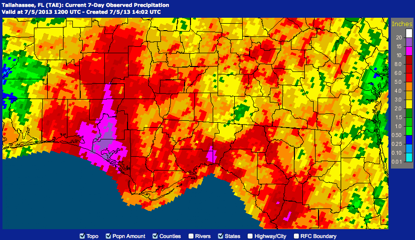
Here are 7 day rainfall totals across that region, with most of it falling in the past two days.
North Alabama has had some very impressive totals as well:
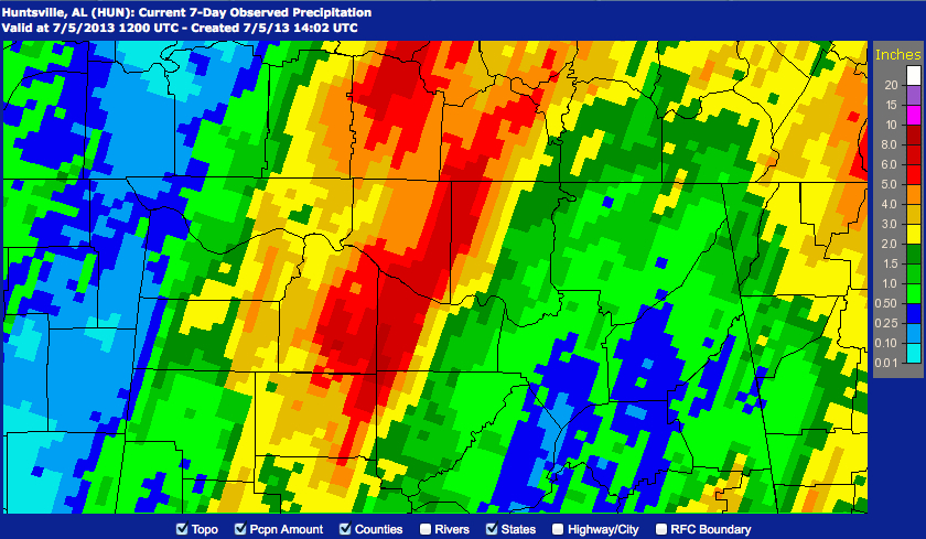
The Bankhead Forestry Station picked up 8.29 inches. Decatur measured an impressive 6.18 inches. All that just yesterday!
And all of this from a non-tropical system.
Here is the radar across Central Alabama at 11 a.m.
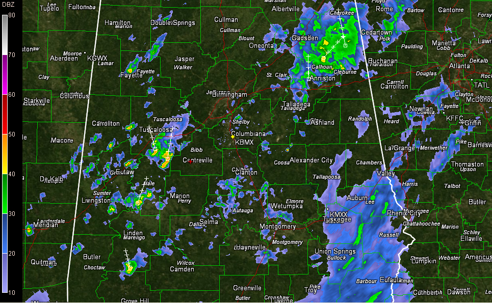
A band of showers seems to be filling in now from Pickens and Tuscaloosa Counties through southern Jefferson, Shelby and Talladega Counties, southward for about 100 miles.
Additional showers were building over Northwest Alabama. And there is a large area of rain over the Southeast part of the state.
Also, a huge surge of moisture and associated showers and storms was building from southeastern Louisiana to the Northwest Florida Panhandle. This seems to be in conjunction with a bit of a jetstreak in the upper atmosphere that is producing favorable conditions for development in its right rear quadrant. As that jetstreak moves across Mississippi today, it could set the stage for widespread heavy rain to develop over parts of the state. Areas along and west of I-65 look like they may receive the heaviest rain today. The Tennessee Valley could as well.
Flash flood watches remain in effect for all 67 Alabama counties. Please stay weather aware through tomorrow. And remember, turn around, don’t drown!
Category: Alabama's Weather
About the Author (Author Profile)
Bill Murray is the President of The Weather Factory. He is the site's official weather historian and a weekend forecaster. He also anchors the site's severe weather coverage. Bill Murray is the proud holder of National Weather Association Digital Seal #0001 @wxhistorianSubscribe
If you enjoyed this article, subscribe to receive more just like it.


