

Warming Up; Storms By Thursday Night
An all new edition of the ABC 33/40 Weather Xtreme video is available in the player on the right sidebar of the blog. You can subscribe to the Weather Xtreme video on iTunes by clicking here.
WARMING TREND: Alabama’s weather will turn warmer through mid-week as an upper ridge builds over the Deep South ahead of a deep upper trough out west. We project a high in the upper 70s today and close to 80 degrees tomorrow, well above our average high of 70 here in late October. Days will be partly sunny, and there is no significant chance of rain with the warmer air aloft over us.
HALLOWEEN STORM SYSTEM: SPC has defined a “slight risk”, which is their standard risk, of severe weather Thursday afternoon and Thursday night for parts of the Mid-South…
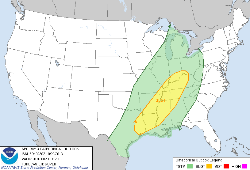
As you can see, the risk extends into Northwest Alabama for areas generally west of a line from Huntsville to Millport. There is a higher risk (30 percent) for cities like Florence, Memphis, and Tupelo. After a careful review of the latest model set, here are our thoughts on the storms…
TIMING: Showers and storms could enter the northwest corner of Alabama (Muscle Shoals, Florence, etc) as early as 5:00 Thursday afternoon. For Birmingham, Tuscaloosa, Anniston, and Gadsden, the main threat of showers and storms will come after 7:00 p.m. Thursday. The GFS is a little faster on recent runs, and we have adjusted the time a bit in respect to this trend.
Will the trick or treaters get wet? It all depends on where you live, and when they want to head out. Needless to say, the earlier they can go, the better. Storms won’t arrive until after 9:00 for areas south and east of Birmingham, most likely.
SEVERE WEATHER THREAT: The low level (surface to 925 mb) bulk shear values are actually pretty high around places like Memphis and Jackson, TN, and Greenville, MS late Thursday afternoon (30 knots or higher). This is where SPC has the enhancement in their severe weather outlook, and despite limited instability there could be a tornado or two in this zone (Northwest Mississippi, West Tennessee) from about 3:00 p.m. until 7:00 p.m. Can’t totally rule out an isolated tornado over the northwest corner of Alabama as well Thursday evening.
However, the bulk shear values really fall off after 7:00 p.m., and for most of North/Central Alabama the tornado threat looks very low Thursday night. And, the overall severe weather threat will decrease with time as the storms move east. Surface based instability values remain very low (surface based CAPE values under 500 j/kg), which is a limiting factor. Storms could be marginally severe in spots, with the main threat coming from strong straight line winds, and mainly for areas north and west of Birmingham.
But, as I always say, when it comes to thunderstorms expect the unexpected, so we will watch model trends closely as the event gets closer. Take some time to watch the Weather Xtreme video for all of the maps, graphics, and more details.
RAIN AMOUNTS: Most communities will see rain totals from one to one and a half inches; flooding issues are not expected.
FRIDAY: The rain will end from west to east during the day Friday. The rain will be gone in time for high school football games Friday night, but the fields will be pretty wet.
THE ALABAMA WEEKEND: Cool and dry weather is the story; highs drop into the 60s, and by early Sunday the low around here will be in the 38-42 degree range. Expect a mostly sunny sky Saturday and Sunday.
NEXT WEEK: Another potent storm system is due in here around the middle of the week, on Wednesday November 6; too early to really know if severe weather will be an issue. The months of November and December represent our fall tornado season, it is very “normal” to have active thunderstorm events this time of the year.
WEATHER BRAINS: Don’t forget you can listen to our weekly 90 minute netcast anytime on the web, or on iTunes. This is the show all about weather featuring many familiar voices, including our meteorologists here at ABC 33/40.
CONNECT: You can find me on all of the major social networks…
Facebook
Twitter
Google Plus
Instagram
I will be in Gadsden later this morning for a weather program at Episcopal Day School… look for the next Weather Xtreme video here by 4:00 this afternoon. Enjoy the day!
Category: Alabama's Weather
About the Author (Author Profile)
James Spann is one of the most recognized and trusted television meteorologists in the industry. He holds the AMS CCM designation and television seals from the AMS and NWA. He is a past winner of the Broadcast Meteorologist of the Year from both professional organizations.Subscribe
If you enjoyed this article, subscribe to receive more just like it.


