

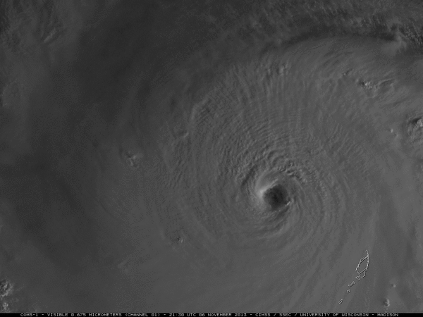
A Close-up of Super Typhoon Haiyan
This close-up of Super Typhoon Haiyan shows structural features rarely seen in such powerful storms. Because of the time difference these images are delayed a day, but these features continue to show up on other current satellite products. Haiyan is a very well organized system and it is amazing to be able to look down into this very powerful storm. From up above we can see down into the eye and we have a clear view down to the ocean’s surface. Within the eye, small vortices are rotating around a seemingly calm center and these small vortices are mini areas of circulation within the broader center of circulation.
Another beautiful feature with this storm are the towering thunderstorms that look like bubbling mud or the tops of cauliflower, especially in the outer bands. These overshooting tops are allowing for shadows to be cast in certain areas of the storm, which enhances their texture and causes them to stand out even more. As the sun sets towards the end of the animation, you will notice the sun still hitting the top of the eastern eyewall, showing just how tall the storms are at the center of circulation.
This is very dangerous storm with sustained winds of 195 mph with gust over 235 mph. Haiyan continues to move towards the west-northwest and will be crossing and likely devastating portions of the Philippines over the next 24 hours.
About the Author (Author Profile)
Macon, Georgia Television Chief Meteorologist, Birmingham native, and long time Contributor on AlabamaWX. Stormchaser. I did not choose Weather, it chose Me. College Football Fanatic. @Ryan_StinnetSubscribe
If you enjoyed this article, subscribe to receive more just like it.


