

Some Snow For Alabama Late Tonight
An all new edition of the ABC 33/40 Weather Xtreme video is available in the player on the right sidebar of the blog. You can subscribe to the Weather Xtreme video on iTunes by clicking here.
THIS AFTERNOON: We are getting a break in the soaking rain this afternoon across Alabama, but low clouds are hanging tough with drizzle reported in most places. Will put together a list of rain totals from our Skywatchers later, but it looks like rain amounts of 2 to 4 inches were common over the past 24 hours.
Temperatures are only in the 40s; the average high for November 26 is 61.
SNOW TONIGHT: We have been watching the upper low near Houston with great interest, snow has been reported in places like Huntsville, Texas, and even some of the northern suburbs of Houston. We will see the dynamic cooling associated with that feature late tonight, and with cold air advection confidence is high we will see a little snow across Alabama. Here is our thinking, pretty much in line with forecasts we have issued in recent days.
TIMING: The greatest chance of snow over North and Central Alabama will come from about 11:00 p.m. until 4:00 a.m. A few spots might see a flake or two as early as 10:00. Most people will sleep right through this event.
PLACEMENT: Snow flakes are possible anywhere over the northern half of Alabama, and a few flakes could be seen as far south as Alabama 22 (Selma to Clanton to Roanoke). The heavier snow rates should be east of I-65. The snow should last 1 to 2 hours in most cases.
ACCUMULATION? The ground is very wet, and much of the snow will simply melt as it falls. But, there is a chance of some accumulation on grassy areas around the Birmingham metro and points north and east. Below is the 12Z high res NAM’s show depth projection at daybreak tomorrow.
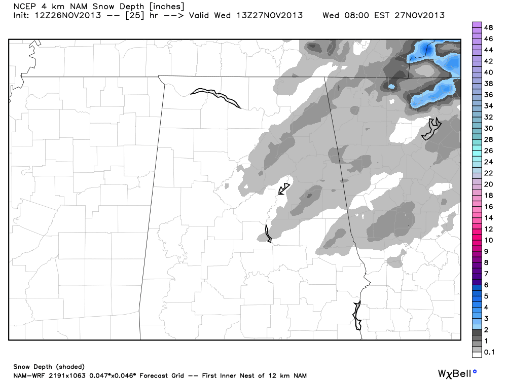
I do think some of the higher terrain spots over Jackson and DeKalb Counties could see one inch of snow in the grass… amounts of 1/4 to 1/2 inch are possible in spots over Madison, Marshall, Cullman, Cherokee, Blount, Etowah, Calhoun, St. Clair, and Cleburne Counties. I do not expect any snow accumulation on roads; they will remain wet, and travel problems due to the snow are not expected. However…
ICE SPOTS ON BRIDGES: Temperatures should drop below freezing around 2-3 a.m., and we expect mid to upper 20s by daybreak tomorrow. This means that standing water will freeze, and there is a very real chance of icy spots on bridges and overpasses. So, if you are driving early tomorrow morning, watch out for those patches of ice; you don’t want to get into a wreck on Thanksgiving Eve.
Similar conditions are likely up into Tennessee, where icy spots are possible on bridges and overpasses, especially from I-65 east. No travel problems are expected over West Tennessee or Arkansas.
Take some time to watch the Weather Xtreme video for more details on travel weather, along with maps and graphics.
WINDY AND COLD TOMORROW: The sky will clear tomorrow morning with sunshine returning, but the day will be cold and windy with temperatures holding in the 30s. A strong north wind of 15-25 mph will keep the wind chill index below freezing much of the day.
Tomorrow night the wind will die down, and we expect lows in the 17-23 degree range by daybreak Thanksgiving. It will be a very cold start to the day.
THURSDAY THROUGH THE WEEKEND: Thanksgiving Day will feature sunshine in full supply with a high in the mid 40s. For Black Friday, be aware that early morning temperatures will be in the 20s, but we warm into the low to mid 50s by afternoon with a good supply of sunshine.
The weather will stay dry Saturday and Sunday with highs in the mid to upper 50s; clouds will begin to increase Sunday, and we might consider a slight risk of a shower Sunday night and Monday with a disturbance aloft passing overhead. Doesn’t look like a big rain event.
IRON BOWL WEATHER: Doesn’t get any better. A sunny sky for Saturday’s Alabama/Auburn game at Jordan-Hare Stadium (2:30p CT kickoff); about 56 degrees at kickoff, 50 degrees at the final whistle. No chance of rain.
WEATHER BRAINS: Don’t forget you can listen to our weekly 90 minute netcast anytime on the web, or on iTunes. This is the show all about weather featuring many familiar voices, including our meteorologists here at ABC 33/40.
CONNECT: You can find me on all of the major social networks…
Facebook
Twitter
Google Plus
Instagram
I had a great time today visiting with the kids at Holt Elementary School… be looking for them on the Pepsi KIDCAM today at 5:00 on ABC 33/40 News! The next Weather Xtreme video will be posted here by 7:00 a.m. tomorrow…
Category: Alabama's Weather
About the Author (Author Profile)
James Spann is one of the most recognized and trusted television meteorologists in the industry. He holds the AMS CCM designation and television seals from the AMS and NWA. He is a past winner of the Broadcast Meteorologist of the Year from both professional organizations.Subscribe
If you enjoyed this article, subscribe to receive more just like it.


