

Coldest Night In Eighteen Years
An all new edition of the ABC 33/40 Weather Xtreme video is available in the player on the right sidebar of the blog. You can subscribe to the Weather Xtreme video on iTunes by clicking here.
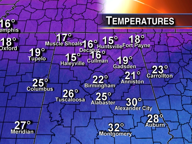
TOO COLD: Temperatures this afternoon are only in the mid teens over much of Alabama north of Birmingham, with wind chill index values below zero in many places.
Keep in mind we should be in the low 50s here in early January. And, these temperatures are with sunshine now in full force.
BITTERLY COLD NIGHT: We are still forecasting a low between 5 and 10 degrees early tomorrow; it should be our coldest night since February 5, 1996 when our low was 6 degrees. The wind will be in the 5-10 mph range, and the wind chill index will be below zero in many places at daybreak tomorrow.
SUB-FREEZING WEATHER CONTINUES TOMORROW: Despite a sunny sky, we won’t get past the mid 20s tomorrow. At least the wind won’t be as fierce as today; it will be generally under 5 mph by afternoon as the surface high drifts over us.
WEDNESDAY: Another very cold morning. We start the day in the 10-15 degree range, but finally climb above freezing by late morning, ending 60 or so consecutive hours below freezing. The sky will remain mostly sunny.
THURSDAY/FRIDAY: These two days look pretty dry for Alabama based on the 12Z run of the GFS; there is some potential for freezing rain/ice issues over Arkansas Thursday, but it looks like that won’t impact us. And, the warming trend continues. We reach the mid 50s Thursday, and upper 50s Friday as we continue to dig out of the deep freeze.
THE ALABAMA WEEKEND: The next good chance of rain comes late Friday night and Saturday. We might even see some thunder Saturday as a warm front passes north of here; the GFS is printing a high of 70 degrees Saturday afternoon. Not sure it gets that warm, but we will easily make the 60s. Rain amounts of 1/2 to 3/4 of an inch look likely. Then, for now Sunday looks mostly rain-free as the moisture axis moves to the east. The high Sunday will be close to 60 degrees.
VOODOO LAND: The GFS brings in more cold air in the January 17-21 time frame, and even hints at some winter weather mischief, then later in the month the model really warms up much of the nation as the AO (Arctic Oscillation) goes strongly positive. See the Weather Xtreme video for the maps, graphics, and details.
WEATHER BRAINS: Don’t forget you can listen to our weekly 90 minute netcast anytime on the web, or on iTunes. This is the show all about weather featuring many familiar voices, including our meteorologists here at ABC 33/40. We will actually produce this week’s show tomorrow night at 8:30p CT.
CONNECT: You can find me on all of the major social networks…
Facebook
Twitter
Google Plus
Instagram
Look for the next Weather Xtreme video here by 7:00 a.m. tomorrow…
Category: Alabama's Weather
About the Author (Author Profile)
James Spann is one of the most recognized and trusted television meteorologists in the industry. He holds the AMS CCM designation and television seals from the AMS and NWA. He is a past winner of the Broadcast Meteorologist of the Year from both professional organizations.Subscribe
If you enjoyed this article, subscribe to receive more just like it.


