

More Very Cold Air Next Week
An all new edition of the ABC 33/40 Weather Xtreme video is available in the player on the right sidebar of the blog. You can subscribe to the Weather Xtreme video on iTunes by clicking here.
FRIGID FRIDAY MORNING: Let’s look at some pre-dawn temperatures around the great state of Alabama. Keep in mind these are not lows… just a snapshot at 5:00 a.m. Some places will see lows a degree or two colder.
Valley Head 3
Black Creek (just northeast of Gadsden) 4
Fort Payne 5
Cullman 7
Russellville 7
Gadsden 8
Onenota 9
Jacksonville 9
Chelsea 15
Bessemer 15
Anniston 15
Birmingham 16 (wind chill index 5)
Fayette 17
Tuscaloosa 20 (wind chill index 10)
THE DAY AHEAD: Today’s high will be only in the low to mid 30s, but at least the sun will be out, and there will be very little wind through the midday and afternoon.
THE ALABAMA WEEKEND: After a low tomorrow morning in the 20s, we will see a temporary warm-up. The high tomorrow will be in the upper 40s, followed by low 50s Sunday. Dry air stays in place and the sky will be mostly sunny both days.
MORE ARCTIC AIR NEXT WEEK: We go right back in the deep freeze; a chance we see mid to upper 40s Monday, but temperatures should begin to fall during the afternoon hours over North Alabama as the cold air rushes in on brisk north winds.
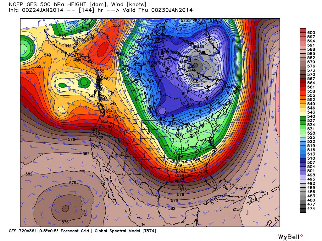
The 00Z GFS is suggesting we go below freezing Monday evening, and stay below freezing until late Thursday morning (at Birmingham). Another long duration period of sub-freezing temperatures. The model is printing these lows for Birmingham…
Tuesday morning 15
Wednesday morning 8
Thursday morning 18
This will change, of course, as we get closer to the event, but clearly we will be dealing with another brutally cold airmass with a high amplitude upper trough over the eastern half of North America with a cross Polar flow.
LATE NEXT WEEK: Snow lovers are hoping the impulse at the end of next week will bring them a few flakes. Unfortunately the 06Z GFS is now bone dry for Friday (January 31), but the ECMWF still shows potential for some light precipitation. Thermal fields look like mostly rain, however, during the day. If it begins early enough, we might see a little freezing rain, sleet, or snow very early Friday morning, but there is very low confidence in any specific forecast now. I will have a pretty good idea of what happens by Sunday night and Monday morning. Stay tuned.
WEATHER BRAINS: Don’t forget you can listen to our weekly 90 minute netcast anytime on the web, or on iTunes. This is the show all about weather featuring many familiar voices, including our meteorologists here at ABC 33/40.
CONNECT: You can find me on all of the major social networks…
Facebook
Twitter
Google Plus
Instagram
I am doing a weather program this morning at Memorial Park Elementary School in Jasper… look for the next Weather Xtreme video here by 4:00 this afternoon. Enjoy the day and stay warm!
Category: Alabama's Weather
About the Author (Author Profile)
James Spann is one of the most recognized and trusted television meteorologists in the industry. He holds the AMS CCM designation and television seals from the AMS and NWA. He is a past winner of the Broadcast Meteorologist of the Year from both professional organizations.Subscribe
If you enjoyed this article, subscribe to receive more just like it.


