

Possible Rainfall Totals the Next Few Days
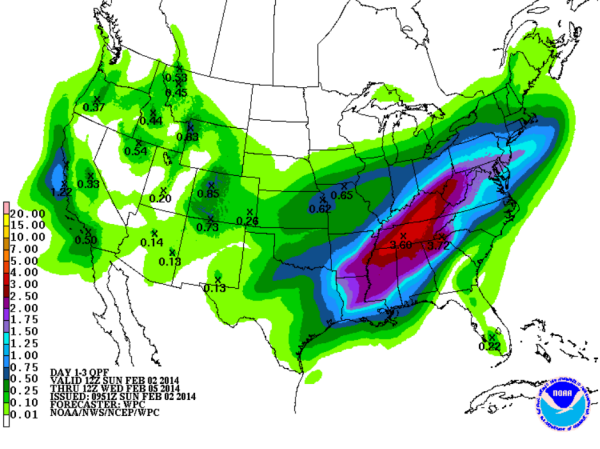
Much of the Southeast well have a couple of rounds of showers and thunderstorms to next few days. We have a very moist air mass in place as precipitable water values range 1.5 to 3 inches across the state. Looking at the QPF off the GFS model from this morning shows a very wet time between now and Wednesday morning.
Locations across the northern half of Alabama are forecast to see the most rain as the northern half of the state will see upwards to two inches. Across the Tennessee Valley, even higher totals expected where three inches are possible. We have been dry lately, so the ground is expected to hold the amount of rainfall forecast rather well. At this time, no flooding is expected.
Even higher totals are expected across Tennessee and Kentucky, but much of that precip will be in the form of snow and ice. The two main waves of precip expected across the region will be this evening and overnight, then again on Tuesday and Tuesday night as frontal boundaries will enhance the uplift across the region and cause heavy rain at times and even some thunderstorms.
Category: Alabama's Weather
About the Author (Author Profile)
Macon, Georgia Television Chief Meteorologist, Birmingham native, and long time Contributor on AlabamaWX. Stormchaser. I did not choose Weather, it chose Me. College Football Fanatic. @Ryan_StinnetSubscribe
If you enjoyed this article, subscribe to receive more just like it.


