

Winter Storm Watch Issued for Monday Night
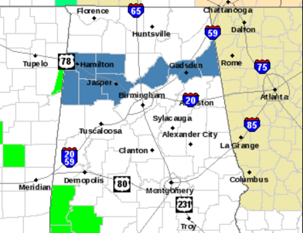
The National Weather Service in Birmingham has issued a Winter Storm Watch for some of our northern counties for Monday night into Tuesday morning. The counties in blue are under this watch. They include Marion, Lamar, Fayette, Winston, Walker, Blount, Etowah, and Cherokee. At this time, the watch does not include Birmingham, Tuscaloosa, or Anniston.
This watch is valid from 6 PM Monday February 10th until noon Tuesday February 11th. There is no winter weather expected the rest of this weekend. The rest of the weekend will have mild afternoons and terrific weather. Clouds should begin to move back into the area late Sunday and rain should return during the day Monday. Monday night, as moisture increases and colder weather moves in, there will be a chance for wintry precip. There is still plenty of time to watch this and make preparations.
…WINTER STORM POSSIBLE FOR PORTIONS OF NORTH CENTRAL ALABAMA
MONDAY NIGHT THROUGH LATE TUESDAY MORNING…
.AN UPPER LEVEL DISTURBANCE TO THE NORTH OF CENTRAL ALABAMA
COMBINED WITH TEMPERATURES FALLING BELOW FREEZING AT THE SURFACE
MONDAY EVENING MAY RESULT IN WINTRY PRECIPITATION ACROSS PORTIONS
OF NORTH CENTRAL ALABAMA MONDAY NIGHT THROUGH LATE TUESDAY MORNING.
ACCUMULATIONS OF SNOW…SLEET…AND FREEZING RAIN WILL ALL BE
POSSIBLE.
THERE ARE STILL TIMING AND PLACEMENT ISSUES WITH THE WINTRY
PRECIPITATION THAT WILL NEED TO BE WORKED OUT OVER THE NEXT DAY OR
SO. CHECK BACK OFTEN FOR REFINEMENTS TO THE FORECAST AS MONDAY
EVENING APPROACHES.
MARION-LAMAR-FAYETTE-WINSTON-WALKER-BLOUNT-ETOWAH-CHEROKEE-
INCLUDING THE CITIES OF…HAMILTON…SULLIGENT…VERNON…
FAYETTE…JASPER…ONEONTA…GADSDEN…CENTRE
…WINTER STORM WATCH IN EFFECT FROM MONDAY EVENING THROUGH
TUESDAY MORNING…
THE NATIONAL WEATHER SERVICE IN BIRMINGHAM HAS ISSUED A WINTER
STORM WATCH…WHICH IS IN EFFECT FROM MONDAY EVENING THROUGH
LATE TUESDAY MORNING.
* TIMING…FROM 6 PM MONDAY EVENING THROUGH NOON TUESDAY.
* LOCATION…AT THIS TIME…THE BEST POTENTIAL FOR SIGNIFICANT
SNOW…SLEET…AND FREEZING RAIN ACCUMULATIONS WILL BE FOR
LOCATIONS GENERALLY NORTH OF A LINE FROM MILLPORT TO ONEONTA TO
CENTRE.
* ACCUMULATIONS…THERE IS A POTENTIAL FOR MORE THAN 2 INCHES OF
SNOW AND SLEET COMBINED ACROSS THE WATCH AREA…AS WELL AS UP TO
TWO TENTHS OF AN INCH OF FREEZING RAIN ACCUMULATION.
PRECAUTIONARY/PREPAREDNESS ACTIONS…
A WINTER STORM WATCH MEANS THERE IS A POTENTIAL FOR SIGNIFICANT
SNOW…SLEET…OR ICE ACCUMULATIONS THAT MAY IMPACT TRAVEL.
CONTINUE TO MONITOR THE LATEST FORECASTS.
Category: Alabama's Weather, Winter Weather
About the Author (Author Profile)
Macon, Georgia Television Chief Meteorologist, Birmingham native, and long time Contributor on AlabamaWX. Stormchaser. I did not choose Weather, it chose Me. College Football Fanatic. @Ryan_StinnetSubscribe
If you enjoyed this article, subscribe to receive more just like it.


