

A Wintry Mess this Morning
We are seeing those temps approach the freezing mark along Interstate 20. Temps of 32-33 are being reported and the 32 degree isotherm is now into Tuscaloosa, Jefferson, and St. Clair counties. That means we are now entering into a time of transition to frozen precip and icing conditions. From here on out, road and travel conditions will deteriorate. Do not be out on the roads. There will be a very narrow strip of where there will be all rain to ice and all frozen precip.
The heaviest accumulations we are seeing continue to be along and north of U.S. 278 where frozen precip has been falling for several hours. Snow is accumulating on many surfaces and there are reports of bridge icing in Marion, Winston, Cullman, and DeKalb counties. Snow and ice are covering the roadways in many areas. Along with the issues of slick spots impacting U.S.278, there are also reports of ice and slick spots on Interstate 22 and Interstate 65.
Latest check of the radar, we continue to see quite the wintry mess over Alabama. Once again, moderate to heavy snow accumulating in our northern counties. A persistent wintry mix for Jasper, Cordova, and northern suburbs of Tuscaloosa and Birmingham. There have been reports of some icing throughout Jefferson County this morning and we expect these reports to ramp up the next few hours. Once the temperature at your location drops to 32 or lower, expect ice build up and travel hazards.
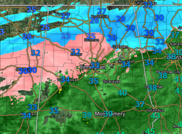
Several reports via social media of elevated surfaces have a light glaze on them along the Intestate 20 corridor already.
To the south of this area, it remains all rain. As the cold air slips to the south a little more, we are expecting to see a wintry mix.
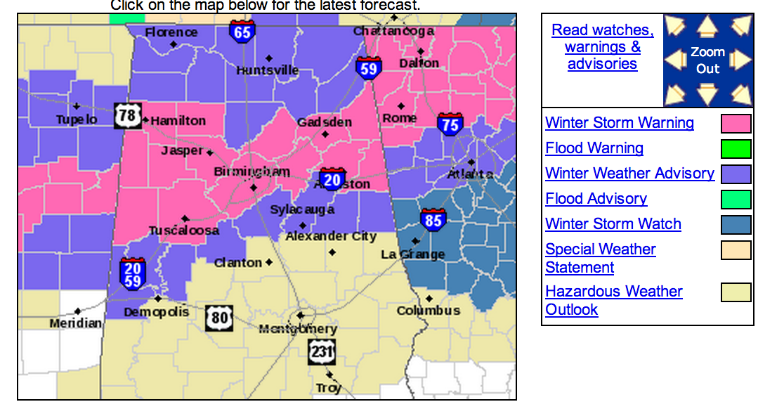
Remember that much of the area remains under either a Winter Storm Warning or a Winter Weather Advisory. Icing will become a major threat over the next few hours in Central Alabama. To the north of the ice, expect several inches of sleet and snow.
More reports from north-central Mississippi have roads icy and covered in snow. Many areas are reporting a glaze of ice on everything, including trees, utility lines, and cars. Similar conditions are expected in Central Alabama throughout the morning. The next several hours are when we expect the greatest accumulations of ice in Central Alabama. Rain and cooling temps are setting the stage for a very interesting morning across Central Alabama.
Category: Alabama's Weather, Winter Weather
About the Author (Author Profile)
Macon, Georgia Television Chief Meteorologist, Birmingham native, and long time Contributor on AlabamaWX. Stormchaser. I did not choose Weather, it chose Me. College Football Fanatic. @Ryan_StinnetSubscribe
If you enjoyed this article, subscribe to receive more just like it.


