

Severe Storms Possible Tonight
An all new edition of the ABC 33/40 Weather Xtreme video is available in the player on the right sidebar of the blog. You can subscribe to the Weather Xtreme video on iTunes by clicking here.
WARM WINTER DAY: We are projecting a high in the mid 70s today… just a few degrees away from the record high for February 20, 78 set in 1986. South winds will really pick up this afternoon as a surface low deepens over the Midwest. The sky will be mostly cloudy, and a few scattered showers are possible.
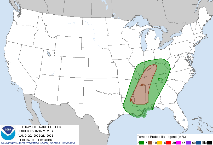
LINE OF STRONG/SEVERE STORMS TONIGHT: SPC has upgraded the severe weather risk to “moderate” for the far northwest corner of Alabama; the enhanced “moderate risk” covers parts of North Mississippi, West and Middle Tennessee, and Central Kentucky. The standard “slight risk” runs from the Gulf Coast to near Indianapolis and Cincinnati.
Here are projected storm arrival times from the NWS Birmingham…
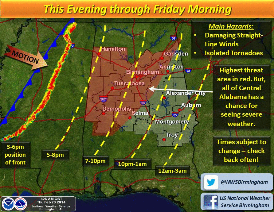
We do note the high resolution NAM has trended slower, hinting it might be midnight before the main band of storms arrives in Birmingham.
MODES OF SEVERE WEATHER: As we have stated in recent days, clearly the primary threat tonight is from strong wind gusts along the line of storms, possibly exceeding 50 mph in spots. The higher probabilities of severe wind gusts are along and north of I-59; the storms should slowly weaken as they move into East Alabama, but the risk of severe weather will continue all the way to the Georgia border.
Winds could be high enough in spots to knock down trees and power lines.
A small spin-up tornado somewhere along the line can’t be ruled out, but the higher tornado probabilities are generally west of Alabama (5 percent over much of Mississippi).
It is likely that severe weather watches and warnings will be needed tonight, so be sure you are in a position to hear them (NOAA Weather Radio, smart phone apps, etc). The storms will move out of Alabama after midnight.
TOMORROW/SATURDAY: These two days will feature sunny pleasant afternoons and fair, chilly nights. The high tomorrow will be near 60, followed by mid 60s Saturday. The low early Saturday morning will be down in the mid 30s.
SUNDAY: A wave will bring clouds to Alabama, but the best chance of rain will come over the southern half of the state, especially south of Montgomery. But, a sprinkle or two can’t be ruled out as far north as I-20. The high will remain in the 60s.
NEXT WEEK: The upper trough becomes re-established over the eastern half of North America, and colder air will return. Looks like it will be a mostly dry week for Alabama, with the colder air seeping in here Wednesday and Thursday. I think the GFS might be too warm; I would not be surprised if highs were in the 40s on those two days. See the Weather Xtreme video for the maps, graphics, and more details.
WEATHER BRAINS: Don’t forget you can listen to our weekly 90 minute netcast anytime on the web, or on iTunes. This is the show all about weather featuring many familiar voices, including our meteorologists here at ABC 33/40.
CONNECT: You can find me on all of the major social networks…
Facebook
Twitter
Google Plus
Instagram
I have a weather program this morning in Blount County at Mt. Pleasant Christian School… look for the next Weather Xtreme video here by 4:00 this afternoon. Enjoy the day!
Category: Alabama's Weather
About the Author (Author Profile)
James Spann is one of the most recognized and trusted television meteorologists in the industry. He holds the AMS CCM designation and television seals from the AMS and NWA. He is a past winner of the Broadcast Meteorologist of the Year from both professional organizations.Subscribe
If you enjoyed this article, subscribe to receive more just like it.


