

Severe Storms Arrive Tonight
An all new edition of the ABC 33/40 Weather Xtreme video is available in the player on the right sidebar of the blog. You can subscribe to the Weather Xtreme video on iTunes by clicking here.
BALMY WINTER AFTERNOON: As expected, it is a warm and windy day across the great state of Alabama ahead of a deepening storm system over the Midwest. Tuscaloosa has soared to 78 degrees at 2:00; that is a new record high for February 20 (old record was 77 set in 1986). There are a few scattered showers around, but nothing heavy or widespread.
TO THE WEST: Thunderstorms continue to increase in coverage and intensity. A tornado watch is up for much of North Mississippi and West Tennessee until 9p CT, and SPC maintains a moderate risk from North MS to Central KY.
ALABAMA’S SEVERE WEATHER THREAT: Not much change in our thinking tonight, although it looks like the storms might arrive a little later than expected early this morning.
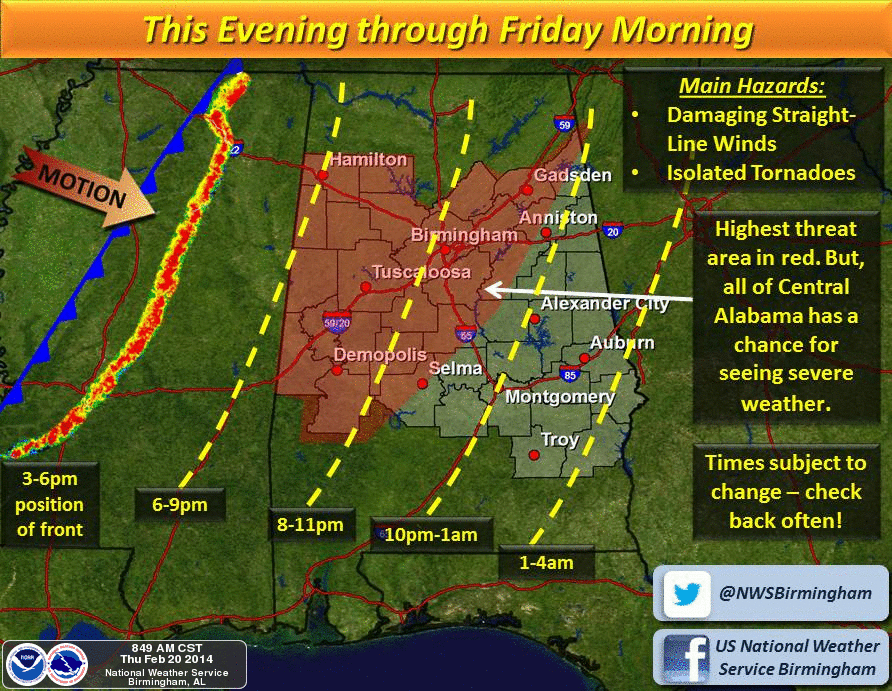
The storms will enter West Alabama in the 7-8 p.m. time frame, then moving steadily eastward until exiting the state after midnight. Some of the better high resolution models have the squall line in the Birmingham metro around in the 11:00 p.m. to 12:00 a.m. time frame.
THREATS: The main risk continues to be strong straight line wind gusts just ahead of the line, possibly gusting to over 50 mph in spots. This will be enough to knock down some trees and power lines, and a number of severe thunderstorm warnings will most likely be needed. The higher wind damage threat is basically from Birmingham north and west; storms should slowly weaken over East Alabama late tonight, but they still could bring strong winds to the Georgia border.
An isolated tornado or two is possible where there are breaks or bows in the line, but the overall tornado threat for Alabama remains low.
Be sure you can hear severe weather watches and warnings tonight with your NOAA Weather Radio or smart phone apps. A severe weather watch will be required for parts of Alabama early tonight, most likely.
Rain amounts of 1/2 to 1 inch are likely, but no major flooding issues are expected since the line will be moving along at a fairly rapid pace.
See the Weather Xtreme video for a detailed meteorological discussion along with the maps, graphics, and more details.
TOMORROW/SATURDAY: These two days will feature a good supply of sunshine. It will be cooler tomorrow with a high around 60 degrees. Then, on Saturday, we start the day with a low down in the mid 30s, but rise into the mid 60s Saturday afternoon.
SUNDAY: A wave near the Gulf Coast will bring clouds back into Alabama, but most of the rain should be confined to the southern half of the state. A few sprinkles might work their way as far north of I-20, but the significant rain, most likely, will be south of Montgomery. The high will remain in the 60s.
NEXT WEEK: The week looks mostly rain-free, but expect a change back to colder weather by Wednesday and Thursday. The 12Z GFS hints that highs will be in the 50s on these days, but I would not be surprised if it is colder based on the developing pattern. Again, see the Weather Xtreme video for more details and the graphics.
WEATHER BRAINS: Don’t forget you can listen to our weekly 90 minute netcast anytime on the web, or on iTunes. This is the show all about weather featuring many familiar voices, including our meteorologists here at ABC 33/40.
CONNECT: You can find me on all of the major social networks…
Facebook
Twitter
Google Plus
Instagram
I enjoyed seeing the kids today at Mount Pleasant Christian School in Susan Moore… be looking for them on the Pepsi KIDCAM today at 5:00 on ABC 33/40 News! The next Weather Xtreme video will be posted here by 7:00 a.m. tomorrow, and we will have frequent updates tonight as the storms move into Alabama. Stay tuned…
Category: Alabama's Weather
About the Author (Author Profile)
James Spann is one of the most recognized and trusted television meteorologists in the industry. He holds the AMS CCM designation and television seals from the AMS and NWA. He is a past winner of the Broadcast Meteorologist of the Year from both professional organizations.Subscribe
If you enjoyed this article, subscribe to receive more just like it.


