

Rain Moving Out; Colder Air Moving In
An all new edition of the ABC 33/40 Weather Xtreme video is available in the player on the right sidebar of the blog. You can subscribe to the Weather Xtreme video on iTunes by clicking here.
AT DAYBREAK: The good news is that I have heard of no icy bridges over Northwest Alabama early this morning; the rain moved out as the colder air was moving in. It is as cold as 33 degrees in Haleyville at 5:00 a.m. but most communities over Northwest Alabama are above freezing, in the mid 30s, and there are no travel issues being reported. The NWS had a couple of advisories going for parts of North Alabama, but those will be dropped soon.
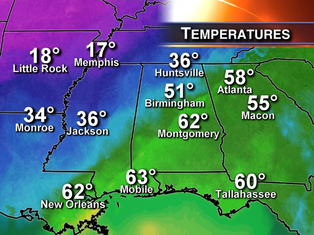
The overall thermal contrast across the Deep South is pretty remarkable, with Montgomery reporting 62 degrees at 5a CT, while Memphis was at 17.
THE DAY AHEAD: Where temperatures are in the 30s over North Alabama, today’s high will be only around 40 degrees. To the south, where they are in the low 60s, temperatures will fall into the 40s and hold there throughout the day. Clouds will hang tough this morning, but a few communities might see a peek of sunshine this afternoon as drier air arrives.
We should mention a freeze is likely tonight for North/Central Alabama; the GFS and the NAM are printing lows in the upper 20s for Birmingham at daybreak tomorrow. Clouds will thicken during the day tomorrow with a high in the low 50s.
THE WEEK AHEAD: Very active weather continues; we will deal with two distinct waves this week that will bring a chance of rain to at least parts of Alabama.
WAVE NUMBER ONE: Rain will move into South Alabama late tomorrow afternoon and should be fairly widespread tomorrow night generally south of U.S. 80, or south of a line from Demopolis to Selma to Montgomery to Opelika.
Places like Birmingham, Anniston, Gadsden, and Tuscaloosa will most likely miss the rain from this wave as all of the wet weather stays just to the south tomorrow night. But, a little rain is possible as far north as Greensboro, Clanton, and Rockford.
Wednesday promises to be a pleasant day with a mix of sun and clouds and a high in the low to mid 60s.
WAVE NUMBER TWO: Another robust short wave will spread rain into all of Alabama on Thursday. Rain amounts of 1/4 to 1/2 inch look likely, and thermal profiles suggest all rain with no ice or sleet issues this time. Temperatures will most likely hold in the chilly 40s Thursday as the rain falls.
FRIDAY AND THE WEEKEND: Friday and Saturday look like two fine early March days, with ample sunshine and highs in the mid to upper 60s. But, a cold front will bring rain back to the state before the weekend is over; latest GFS guidance hints the main window for rain will come from about midnight Saturday night through noon Sunday. No severe weather, and rain amounts of around 1/2 inch look likely. Drier air returns Sunday evening, and the first part of next week looks dry and mild.
LONG RANGE/VOODOO LAND: The good news is that the latest global model runs really don’t show any severe weather threats, or weather mischief through mid-March. See the Weather Xtreme video for the maps, graphics, and details.
WEATHER BRAINS: Don’t forget you can listen to our weekly 90 minute netcast anytime on the web, or on iTunes. This is the show all about weather featuring many familiar voices, including our meteorologists here at ABC 33/40. We will produce this week’s show tonight at 8:30 CT… you can watch it on “James Spann 24/7” on cable systems around the state, or on the web here.
CONNECT: You can find me on all of the major social networks…
Facebook
Twitter
Google Plus
Instagram
I will be seeing the kids with the Greene County Head Start program today, along with kids at Wylam K-8 school in Birmingham for Read Across America Day. Look for the next Weather Xtreme video here by 4:00 or so this afternoon. Enjoy the day!
Category: Alabama's Weather
About the Author (Author Profile)
James Spann is one of the most recognized and trusted television meteorologists in the industry. He holds the AMS CCM designation and television seals from the AMS and NWA. He is a past winner of the Broadcast Meteorologist of the Year from both professional organizations.Subscribe
If you enjoyed this article, subscribe to receive more just like it.


