

Strong Storms over South Alabama
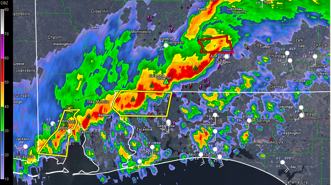
Strong thunderstorms continue over South Alabama this morning. The most intense storms extend from Greenville to Andalusia, Brewton to Spanish Fort and Pascagoula in Mississippi.
Severe thunderstorm warnings are in effect for Escambia/Santa Rosa Counties in Northwest Florida as well as Mobile County in Southwest Alabama. A tornado warning is in effect until 915 for Covington County for a possible tornado near Red Level, or 15 miles northwest of Andalusia.
The strong storms are pushing east at 45 mph.
A tornado watch continues until noon CDT for southeastern Mississippi, southwestern Alabama and three counties in the Florida Panhandle.
The watch comes as far north as Clarke, Wilcox and Butler Counties in Alabama.
A new tornado watch is being considered for additional counties in Northwest Florida.
Further north, it’s just rain and the rain is now mainly east of a line from Roanoke to Alex City to Millbrook to Jackson.
1.63 inches of rain so far at Birmingham since last night. One to two inches of rain have been common with the system.
Behind the main rain area, there will be a few showers during the day, but it should be mainly dry. More showers will move across the area late this afternoon and tonight. The heaviest rain will be south of I-85/65 from Auburn to Montgomery to Mobile.
There will be a few showers on Monday as the upper level trough rotates across the area. It will be cooler as well, with highs struggling to get out of the 40s heading toward highs in the lower 50s.
Category: Alabama's Weather, Severe Weather
About the Author (Author Profile)
Bill Murray is the President of The Weather Factory. He is the site's official weather historian and a weekend forecaster. He also anchors the site's severe weather coverage. Bill Murray is the proud holder of National Weather Association Digital Seal #0001 @wxhistorianSubscribe
If you enjoyed this article, subscribe to receive more just like it.


