Into The 70s Tomorrow
An all new edition of the ABC 33/40 Weather Xtreme video is available in the player on the right sidebar of the blog. You can subscribe to the Weather Xtreme video on iTunes by clicking here.
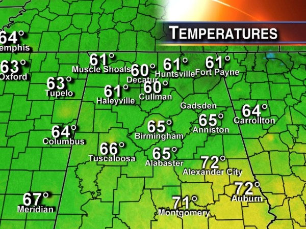
SPRING IS HERE: The weather doesn’t get much better on this first “official” day of spring. The sky is sunny across Alabama with temperatures around here in the 60s; we have low 70s over the southern half of the state.
We rise into the 72-75 degree range tomorrow afternoon with a sunny sky.
FOR THE WEEKEND: The day Saturday will looks mild, and mostly rain-free; with a mix of sun and clouds we will reach the mid 70s; the NAM is printing a high of 77 degrees for Birmingham Saturday afternoon. But, much cooler air invades the state Sunday as a front sags down into South Alabama. Sunday will be cloudy with periods of rain; afternoon temperatures won’t get out of the 50s along and north of I-20, but South Alabama could still see low 70s below the surface front.
The rain on Sunday won’t be too heavy or continuous, but no doubt it will rain at times during the day.
NEXT WEEK: Interesting developments with the 12Z run of the GFS. It now suggests that Monday will be generally cool and dry; clouds stick around, but little rain. Still doubtful we get out of the 50s. Then, a strong wave of low pressure forms in the Northeast Gulf of Mexico on the old front, and spreads rain into Alabama Monday night into early Tuesday morning.
To make it really fun, the GFS hints that snow could fall over far Northwest Alabama in colder air early Tuesday. We won’t buy into this solution for now… the ECMWF is very similar, but thermal fields on that model suggest just a cold rain.
The rain ends by midday Tuesday, but the day will be cloudy and cool with a high only in the low to mid 50s; some North Alabama communities will hold in the 40s all day Tuesday.
LATE SEASON FREEZE: Still looks like a freeze is likely early Wednesday morning for much of North and Central Alabama with lows down in the 20s. Needless to say, it is way too early to be planting anything that might be damaged by freezing temperatures. Sharp cold snaps with frost are pretty much to be expected here into early April.
See the Weather Xtreme video for the maps, graphics, and details.
AT THE BEACH: Mostly sunny days, fair nights on the coast from Panama City to Gulf Shores through Saturday. Then, showers are possible Sunday, with rain more widespread Monday. The rain could be heavy Monday over the Florida Panhandle, in fact. The rest of next week, Tuesday through Friday, should be dry but pretty cool for late March. Temperatures could reach the 40s at night on the Gulf Coast at mid-week.
Afternoon highs on the immediate coast will remain mostly in the low to mid 60s; sea water temperatures are in the 58-62 degree range. That cool ocean water limits the ability for the air to really warm up.
WEATHER BRAINS: Don’t forget you can listen to our weekly 90 minute netcast anytime on the web, or on iTunes. This is the show all about weather featuring many familiar voices, including our meteorologists here at ABC 33/40.
CONNECT: You can find me on all of the major social networks…
Facebook
Twitter
Google Plus
Instagram
I had a great time today visiting with the 6th graders at Centre Middle School… be looking for them on the Pepsi KIDCAM today at 5:00 on ABC 33/40 News! The next Weather Xtreme video will be posted here by 7:00 a.m. tomorrow….
Category: Alabama's Weather


