

Warm Afternoons; Storms By Friday
An all new edition of the ABC 33/40 Weather Xtreme video is available in the player on the right sidebar of the blog. You can subscribe to the Weather Xtreme video on iTunes by clicking here.
WARM SPRING WEATHER: Birmingham’s official high yesterday was 81 degrees… the first time we have seen 80 degree warmth since October 14 of last year. Look for very similar weather today with a mix of sun and clouds, and a high very close to the 80 degree mark. We will mention just a small risk of a shower tonight tomorrow as moisture levels rise… but most locations will stay dry. The high tomorrow will stay near 80 degrees.
ACTIVE WEATHER TO THE WEST: SPC has the standard “slight risk” of severe weather up later today and tonight for much of Oklahoma, Arkansas, and some of the adjacent states. Then, for tomorrow and tomorrow night an enhanced “moderate risk” is up for much of Arkansas, southern Missouri, and parts of West Tennessee and Northwest Mississippi… where a few tornadoes are possible.
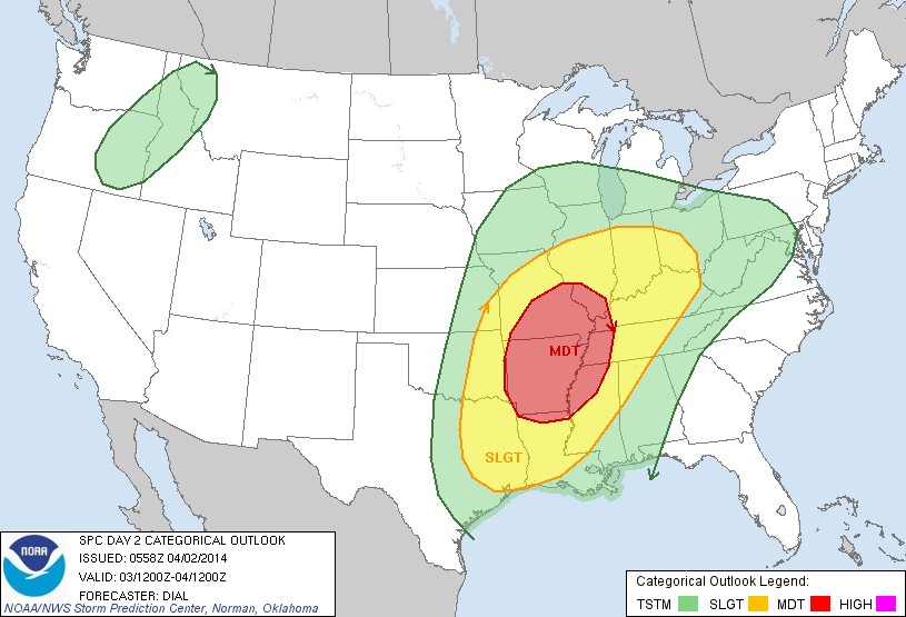
The “slight risk” extends down into Northwest Alabama, mainly for after midnight tomorrow night into early Friday morning (this outlook runs through 7 a.m. Friday).
FRIDAY STORMS: The high resolution NAM suggests the activity northwest of Alabama will consolidate into a squall line late tomorrow night, moving into the northwest corner of Alabama sometime in the 3-4 a.m. time frame early Friday. The storms will have potential to bring strong, possibly damaging winds to places like Florence and Muscle Shoals during the pre-dawn hours Friday, so everyone in the northwest corner of the state will need to be in a position to hear severe weather warnings if needed.
As the storms move southeast, the better dynamic support lifts out, and the should slowly weaken and “fizzle out”. However, SPC has decided to include much of Alabama in a standard “slight risk” of severe weather during the day Friday.
Surface based CAPE values will be over 1,000 j/kg, which is moderate instability. Wind fields and shear values will weaken during the day Friday, and I remain less than impressed with severe weather potential. But, with the SPC “slight risk” in place, and considering this is the first week of April, we will be vigilant and keep a close eye on the situation as we get closer to Friday. See the Weather Xtreme video for the maps, graphics, and more details.
SUNNY SATURDAY: The weekend begins with a sunny day on Saturday. It will be a little cooler with a high around 70 degrees; this is clearly the best day to get outside and get some work done.
MORE RAIN SUNDAY: A surface low will form on the Louisiana coast Sunday, and rain will quickly spread back into Alabama during the day. The GFS moves the low to a point just north of Mobile early Monday, meaning a soaking rain for the state Sunday night into Monday morning. Sunday will be pretty cool with clouds, rain, and an east wind; not sure we get past the low to mid 60s.
The European model (ECMWF) continues to show the low at a higher latitude, northwest of Nashville early Monday. This could put Alabama in the “warm sector” and would mean some risk of strong, maybe even severe thunderstorms Sunday night into early Monday. Getting a decent amount of instability in here after a cool, wet day Sunday will be difficult, but not impossible with this situation. We will have better clarity later in the week.
LATE SEASON FROST/FREEZE NEXT WEEK? Still seeing signs of a big upper trough over the eastern third of the nation by the middle part of next week, and signals of a late season frost/freeze threat for North/Central Alabama by Wednesday or Thursday morning. Too early to be specific, but growers need to be aware of the potential. Still too early to plant anything that will be harmed by frost, or sub-freezing temperatures. Again check out the Weather Xtreme video for more details.
AT THE BEACH: Dry through tomorrow along the Gulf Coast from Panama City west to Gulf Shores; about 6-8 hours of sunshine both days (although they are starting off today with some dense fog) with highs in the 60s along the immediate coast, with 70s inland. Showers and storms are likely Friday through the weekend; there is potential for heavy rain Sunday and Sunday night along with strong storms. Next week will be drier. Sea water temperatures are generally in the low 60s.
NEED HELP WITH YOUR WEATHER RADIO: We will be at Academy Sports on US Highway 11 in Trussville today from 3:30 until 6:30 p.m. If you need your radio programmed, or have questions, come see us.
WEATHER BRAINS: Don’t forget you can listen to our weekly 90 minute netcast anytime on the web, or on iTunes. This is the show all about weather featuring many familiar voices, including our meteorologists here at ABC 33/40. We will produce this week’s show tonight at 8:30 CT… you can watch it on “James Spann 24/7” on cable systems around the state, or on the web here.
CONNECT: You can find me on all of the major social networks…
Facebook
Twitter
Google Plus
Instagram
I will be doing a weather program for the kids at the Children’s Hospital of Alabama this morning… then on to Academy Sports in Trussville for weather programming this evening. I should have time to crank out another Weather Xtreme video this afternoon; it will be posted by 3:00. Enjoy the day…
Category: Alabama's Weather
About the Author (Author Profile)
James Spann is one of the most recognized and trusted television meteorologists in the industry. He holds the AMS CCM designation and television seals from the AMS and NWA. He is a past winner of the Broadcast Meteorologist of the Year from both professional organizations.Subscribe
If you enjoyed this article, subscribe to receive more just like it.


