

Storms Arrive After Midnight
An all new edition of the ABC 33/40 Weather Xtreme video is available in the player on the right sidebar of the blog. You can subscribe to the Weather Xtreme video on iTunes by clicking here.
WARM, BREEZY DAY: South winds will increase across Alabama later today ahead of a major storm system developing over the Southern Plains; those winds will average 10-20 mph with higher gusts. The sky will be occasionally cloudy, but any showers today should be widely spaced and much of the day will be dry. The afternoon high will be in the 77-81 degree range, much like recent days.
TO THE WEST: SPC maintains an enhanced “moderate risk” of severe weather for much of Arkansas, southern Missouri, West Tennessee, and Northwest Mississippi this afternoon and tonight, with the standard “slight risk” all the way from near Corpus Christi, TX to Chicago and Indianapolis…
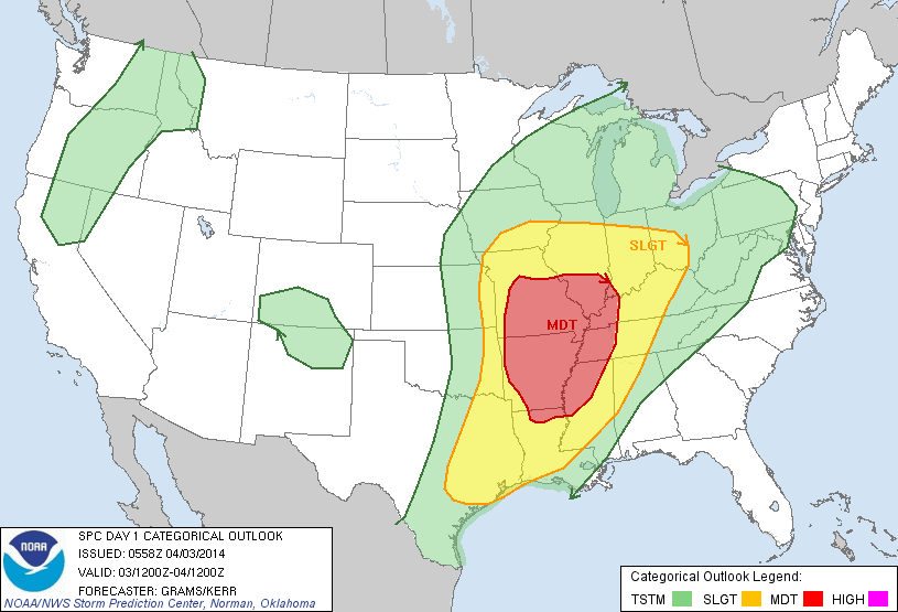
The higher tornado probabilities are centered over Southeast Missouri, and the eastern half of Arkansas. Supercell thunderstorms will form in this region this afternoon as a deepening surface low moves from Oklahoma to Iowa. The storms will evolve into a long QLCS (quasi linear convective system) late tonight as the main threat shifts to strong, potentially damaging straight line winds.
ALABAMA TOMORROW: The high resolution NAM continues to suggest the line of storms will enter the northwest corner of the state sometime in the 4-5 a.m. time frame tomorrow morning, just before daybreak. The storms at that time could be severe, with potential for high winds. The highest severe weather threat will come over Northwest Alabama tomorrow morning between 4:00 and 8:00 a.m.
As the storms move deeper into Alabama tomorrow, they should slowly weaken as the upper support lifts well north of our state. I would say the severe weather threat for the larger cities of Birmingham, Tuscaloosa, Anniston, and Gadsden is very marginal with weak wind fields and marginal shear values by midday. Still, SPC maintains the standard “slight risk” of severe weather for much of our state tomorrow, and this is the first week of April, so we will be watching radar trends very closely.
The showers and storms will end from northwest to southeast tomorrow afternoon as drier air moves into the state.
SUNNY SATURDAY: At least one day this weekend will be nice; Saturday will feature a good supply of sunshine with a high around 70 degrees. If you need to get something done outdoors this weekend, this is the way.
MORE STORMS AS THE WEEKEND ENDS: Clouds return quickly Sunday morning, and a soaking rain/storm event is likely Sunday afternoon through Monday morning as a surface low lifts from the Louisiana coast to Northwest Tennessee. Rain amounts of about two inches are likely, and severe thunderstorms are a very real possibility late Sunday night into early Monday morning. While the instability values are marginal, bulk shear rates are very high, and a tornado threat could be shaping up if the air can destabilize. At this point it looks like the prime window for severe weather in Alabama will come from about midnight Sunday night through 8:00 a.m. Monday. See the Weather Xtreme video for the maps, graphics, and more details.
REST OF NEXT WEEK: Rain ends during the day Monday from west to east, but some light rain is possible Tuesday as an upper trough swings through. Tuesday will be cloudy and cooler with a high only in the low to mid 60s. And, we still will have potential for a late season frost/freeze setup early Thursday morning. Too early to be specific, but growers need to be aware of the potential. Again, see the video for more details.
AT THE BEACH: Mostly dry today along the Gulf Coast from Panama City west to Gulf Shores; about 3-5 hours of sunshine with highs in the 60s along the immediate coast, with 70s inland. Showers and storms are likely tomorrow through the weekend; there is potential for heavy rain Sunday and Sunday night along with strong to severe storms. Next week will be drier. Sea water temperatures are generally in the low 60s.
ON THIS DATE IN 1974: The “Superoutbreak” of tornadoes heavily impacted Alabama; 80 people in our state died… 25 of those deaths were in Guin (in Marion County). Nationally, a total of 148 tornadoes touched down, killing 319 people. It was the largest tornado outbreak on record in our nation up until April 2011. I will be in Guin this morning for a special ceremony honoring those that died, and celebrating the town’s recovery.
WEATHER BRAINS: Don’t forget you can listen to our weekly 90 minute netcast anytime on the web, or on iTunes. This is the show all about weather featuring many familiar voices, including our meteorologists here at ABC 33/40. Scroll down for the show notes on the new episode we recorded last night.
CONNECT: You can find me on all of the major social networks…
Facebook
Twitter
Google Plus
Instagram
Look for the next Weather Xtreme video here by 4:00 this afternoon…. enjoy the day….
Category: Alabama's Weather
About the Author (Author Profile)
James Spann is one of the most recognized and trusted television meteorologists in the industry. He holds the AMS CCM designation and television seals from the AMS and NWA. He is a past winner of the Broadcast Meteorologist of the Year from both professional organizations.Subscribe
If you enjoyed this article, subscribe to receive more just like it.


