

Tornado Warnings Back in Mississippi
A line of severe thunderstorms continues to push eastward across western Mississippi, southeastern Arkansas and northern Louisiana tonight. They are prompting numerous severe thunderstorm warnings and at least three tornado warnings. No reports of actual tornadoes on the ground in the Delta counties of Mississippi yet tonight. The warnings are based on radar indications.
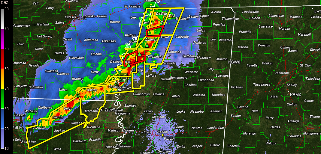
Click image to enlarge.
Tornado watches cover the Mississippi Valley from Central Illinois southward to Central Mississippi and Northeast Louisiana. They also curve back across southern Arkansas and northern Louisiana.
The activity over western Mississippi will arrive in western Alabama around 5 a.m.
The tornado threat has increased a bit to our west early this morning as wind shear has been increasing. But we still expect these storms to weaken after they get into Alabama toward sunrise. They won’t reach the I-59 corridor until later in the morning, between 8:30 a.m. and 10 a.m.
The SPC continues their standard slight risk severe weather outlook through the overnight hours for the northwestern corner of the state. Then a slight risk outlook is posted for the rest of the day for the rest of Central Alabama, with the exception of the I-85 corridor.
Category: Alabama's Weather, Headlines, Severe Weather
About the Author (Author Profile)
Bill Murray is the President of The Weather Factory. He is the site's official weather historian and a weekend forecaster. He also anchors the site's severe weather coverage. Bill Murray is the proud holder of National Weather Association Digital Seal #0001 @wxhistorianSubscribe
If you enjoyed this article, subscribe to receive more just like it.


